East Norwalk geodata
East Norwalk (Connecticut) is a populated place; located in United States in America/New_York (GMT-4) time zone. With population of 84,530 people, there are 458 cities with bigger population in this country. Compared to other cities in United States, 66.9% of cities are located further ↓South; 93.1% of cities are located further ←West and 87.8% of cities have higher elevation than East Norwalk. Note1


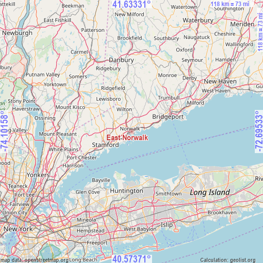
East Norwalk GPS coordinates[2]
41° 6' 20.34" North, 73° 23' 54.42" West
| Map corner | latitude | longitude |
|---|---|---|
| Upper-left | 41.63331°, | -74.10158° |
| Center: | 41.10565°, | -73.39845° |
| Lower-right: | 40.57371°, | -72.69533° |
| Map W x H: | 117.8×117.8 km | = 73.2×73.2mi |
| max Lat: | 71.29058° ⇑33.1% North |
| East Norwalk: | 41.10565° |
| min Lat: | ⇓66.9% South 19.06759° |
| min Long | East Norwalk | max Long |
| -171.73463° | -73.39845° | -66.98998° |
| W 93.1%⇐ | ⇒6.9% E |
Elevation
Elevation of East Norwalk is 21 m = 69 ft, and this is 273.8 m = 898 ft below average elevation for this country.
| Max E: |
3189 m = 10463 ft | 87.8% |
| Avg. | 294.8 m = 967 ft | |
| East Norwalk | 21 m = 69 ft | |
Min E: |
-60 m = -197 ft | 12.2% |
See also: East Norwalk elevation on elevation.city.
Geographical zone
East Norwalk is located in North temperate zone (between Tropic of Cancer and the Arctic Circle). Distance of this Northern Tropic circle is 1964.6 km =1220.7 mi to South.| Distance of | km | miles | from East Norwalk |
|---|---|---|---|
| North Pole | 5436.5 | 3378.1 | to North |
| Arctic Circle | 2830.7 | 1758.9 | to North |
| Tropic Cancer | 1964.6 | 1220.7 | to South |
| Equator | 4570.5 | 2840 | to South |


Nearby cities:
15 places around East Norwalk: (largest is in red/bold)
• Cos Cob
18.7 km =11.6 mi,  244°
244°
• Darien
6.6 km =4.1 mi, 243°
• Easton
18.4 km =11.4 mi,  27°
27°
• Fairfield
12 km =7.5 mi,  70°
70°
• Georgetown
17 km =10.6 mi,  349°
349°
• New Canaan
9.3 km =5.8 mi,  299°
299°
• North Stamford
12.7 km =7.9 mi,  286°
286°
• Norwalk
1.5 km =0.9 mi,  329°
329°
• Old Greenwich
16.7 km =10.4 mi, 236°
• Riverside
17.1 km =10.6 mi, 242°
• Scotts Corners
15.8 km =9.8 mi,  306°
306°
• Southport
10.2 km =6.3 mi, 70°
• Stamford
13.1 km =8.1 mi, 243°
• Westport
5.2 km =3.2 mi,  40°
40°
• Wilton
10.5 km =6.5 mi,  341°
341°
Sources, notices
• [Note1] Compared only with cities in United States existing in our database
• [Src1] Map data: © OpenStreetMap contributors (CC-BY-SA)
• [Src2] Other city data from geonames.org with taken over terms of usage.
• [Src3] Geographical zone / Annual Mean Temperature by Robert A. Rohde @ Wikipedia
