Norwalk geodata
Norwalk (Connecticut) is a populated place; located in United States in America/New_York (GMT-4) time zone. With population of 88,485 people, there are 417 cities with bigger population in this country. Compared to other cities in United States, 67% of cities are located further ↓South; 93% of cities are located further ←West and 89.1% of cities have higher elevation than Norwalk. Note1


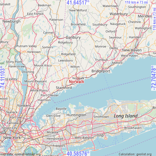
Norwalk GPS coordinates[2]
41° 7' 3.36" North, 73° 24' 28.44" West
| Map corner | latitude | longitude |
|---|---|---|
| Upper-left | 41.64517°, | -74.11103° |
| Center: | 41.1176°, | -73.4079° |
| Lower-right: | 40.58576°, | -72.70478° |
| Map W x H: | 117.8×117.8 km | = 73.2×73.2mi |
| max Lat: | 71.29058° ⇑33% North |
| Norwalk: | 41.1176° |
| min Lat: | ⇓67% South 19.06759° |
| min Long | Norwalk | max Long |
| -171.73463° | -73.4079° | -66.98998° |
| W 93%⇐ | ⇒7% E |
Elevation
Elevation of Norwalk is 18 m = 59 ft, and this is 276.8 m = 908 ft below average elevation for this country.
| Max E: |
3189 m = 10463 ft | 89.1% |
| Avg. | 294.8 m = 967 ft | |
| Norwalk | 18 m = 59 ft | |
Min E: |
-60 m = -197 ft | 10.9% |
See also: Norwalk elevation on elevation.city.
Geographical zone
Norwalk is located in North temperate zone (between Tropic of Cancer and the Arctic Circle). Distance of this Northern Tropic circle is 1965.9 km =1221.6 mi to South.| Distance of | km | miles | from Norwalk |
|---|---|---|---|
| North Pole | 5435.2 | 3377.3 | to North |
| Arctic Circle | 2829.3 | 1758 | to North |
| Tropic Cancer | 1965.9 | 1221.6 | to South |
| Equator | 4571.8 | 2840.8 | to South |


Nearby cities:
15 places around Norwalk: (largest is in red/bold)
• Darien
6.7 km =4.2 mi,  229°
229°
• East Norwalk
1.5 km =0.9 mi,  149°
149°
• Easton
17.7 km =11 mi,  31°
31°
• Fairfield
12.4 km =7.7 mi,  77°
77°
• Georgetown
15.5 km =9.6 mi,  351°
351°
• New Canaan
8 km =5 mi,  294°
294°
• North Stamford
11.6 km =7.2 mi,  281°
281°
• Old Greenwich
16.9 km =10.5 mi, 231°
• Pound Ridge
17.3 km =10.7 mi,  305°
305°
• Riverside
17.1 km =10.6 mi,  236°
236°
• Scotts Corners
14.4 km =8.9 mi,  303°
303°
• Southport
10.6 km =6.6 mi, 78°
• Stamford
13.1 km =8.1 mi, 236°
• Westport
5 km =3.1 mi,  57°
57°
• Wilton
9 km =5.6 mi,  343°
343°
Sources, notices
• [Note1] Compared only with cities in United States existing in our database
• [Src1] Map data: © OpenStreetMap contributors (CC-BY-SA)
• [Src2] Other city data from geonames.org with taken over terms of usage.
• [Src3] Geographical zone / Annual Mean Temperature by Robert A. Rohde @ Wikipedia
