Alcester geodata
Alcester (South Dakota) is a populated place; located in United States in America/Chicago (GMT-5) time zone. With population of 761 people, there are 18118 cities with bigger population in this country. Compared to other cities in United States, 83.5% of cities are located further ↓South; 74.8% of cities are located further →East and 84.8% of cities have lower elevation than Alcester. Note1


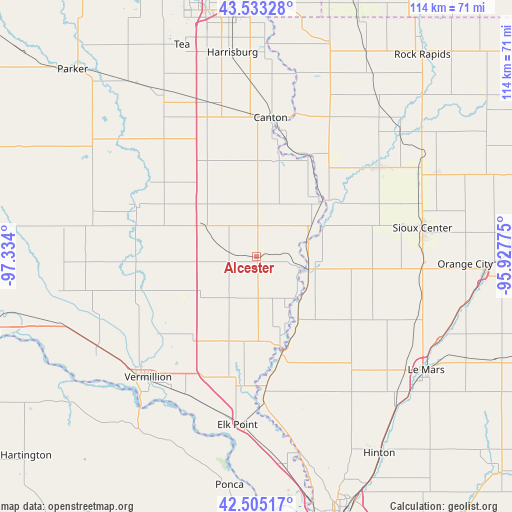
Alcester GPS coordinates[2]
43° 1' 16.968" North, 96° 37' 51.132" West
| Map corner | latitude | longitude |
|---|---|---|
| Upper-left | 43.53328°, | -97.334° |
| Center: | 43.02138°, | -96.63087° |
| Lower-right: | 42.50517°, | -95.92775° |
| Map W x H: | 114.3×114.3 km | = 71×71mi |
| max Lat: | 71.29058° ⇑16.5% North |
| Alcester: | 43.02138° |
| min Lat: | ⇓83.5% South 19.06759° |
| min Long | Alcester | max Long |
| -171.73463° | -96.63087° | -66.98998° |
| W 25.2%⇐ | ⇒74.8% E |
Elevation
Elevation of Alcester is 419 m = 1375 ft, and this is 124.2 m = 407 ft above average elevation for this country.
| Max E: |
3189 m = 10463 ft | 15.2% |
| Alcester | 419 m 1375 ft | |
| Avg. | 294.8 m = 967 ft | |
Min E: |
-60 m = -197 ft | 84.8% |
See also: United States elevation on elevation.city.
Geographical zone
Alcester is located in North temperate zone (between Tropic of Cancer and the Arctic Circle). Distance of this Northern Tropic circle is 2177.6 km =1353.1 mi to South.| Distance of | km | miles | from Alcester |
|---|---|---|---|
| North Pole | 5223.5 | 3245.7 | to North |
| Arctic Circle | 2617.6 | 1626.5 | to North |
| Tropic Cancer | 2177.6 | 1353.1 | to South |
| Equator | 4783.5 | 2972.3 | to South |


Nearby cities:
15 places around Alcester: (largest is in red/bold)
• Akron
22.2 km =13.8 mi,  164°
164°
• Beresford
13.3 km =8.3 mi,  299°
299°
• Canton
31.2 km =19.4 mi,  5°
5°
• Centerville
29 km =18 mi,  292°
292°
• Doon
43.2 km =26.8 mi,  48°
48°
• Elk Point
37.8 km =23.5 mi,  186°
186°
• Hawarden
12.2 km =7.6 mi,  103°
103°
• Inwood
35.6 km =22.1 mi,  26°
26°
• Ireton
25.9 km =16.1 mi, 101°
• Lennox
42.6 km =26.5 mi,  330°
330°
• Rock Valley
34.1 km =21.2 mi, 53°
• Sioux Center
37.6 km =23.4 mi,  80°
80°
• Vermillion
36.3 km =22.6 mi,  222°
222°
• Viborg
40.2 km =25 mi, 294°
• Worthing
35.9 km =22.3 mi,  342°
342°
Sources, notices
• [Note1] Compared only with cities in United States existing in our database
• [Src1] Map data: © OpenStreetMap contributors (CC-BY-SA)
• [Src2] Other city data from geonames.org with taken over terms of usage.
• [Src3] Geographical zone / Annual Mean Temperature by Robert A. Rohde @ Wikipedia
