Avoca geodata
Avoca (Iowa) is a populated place; located in United States in America/Chicago (GMT-5) time zone. With population of 1,504 people, there are 13638 cities with bigger population in this country. Compared to other cities in United States, 70.6% of cities are located further ↓South; 71.9% of cities are located further →East and 80.6% of cities have lower elevation than Avoca. Note1


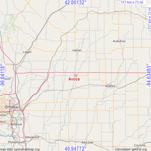
Avoca GPS coordinates[2]
41° 28' 35.976" North, 95° 20' 16.98" West
| Map corner | latitude | longitude |
|---|---|---|
| Upper-left | 42.00132°, | -96.04118° |
| Center: | 41.47666°, | -95.33805° |
| Lower-right: | 40.94772°, | -94.63493° |
| Map W x H: | 117.1×117.1 km | = 72.8×72.8mi |
| max Lat: | 71.29058° ⇑29.4% North |
| Avoca: | 41.47666° |
| min Lat: | ⇓70.6% South 19.06759° |
| min Long | Avoca | max Long |
| -171.73463° | -95.33805° | -66.98998° |
| W 28.1%⇐ | ⇒71.9% E |
Elevation
Elevation of Avoca is 360 m = 1181 ft, and this is 65.2 m = 214 ft above average elevation for this country.
| Max E: |
3189 m = 10463 ft | 19.4% |
| Avoca | 360 m 1181 ft | |
| Avg. | 294.8 m = 967 ft | |
Min E: |
-60 m = -197 ft | 80.6% |
See also: United States elevation on elevation.city.
Geographical zone
Avoca is located in North temperate zone (between Tropic of Cancer and the Arctic Circle). Distance of this Northern Tropic circle is 2005.9 km =1246.4 mi to South.| Distance of | km | miles | from Avoca |
|---|---|---|---|
| North Pole | 5395.3 | 3352.5 | to North |
| Arctic Circle | 2789.4 | 1733.3 | to North |
| Tropic Cancer | 2005.9 | 1246.4 | to South |
| Equator | 4611.8 | 2865.6 | to South |


Nearby cities:
15 places around Avoca: (largest is in red/bold)
• Atlantic
28.2 km =17.5 mi,  106°
106°
• Carson
27.5 km =17.1 mi,  194°
194°
• Elk Horn
26.4 km =16.4 mi,  61°
61°
• Exira
40.5 km =25.2 mi,  71°
71°
• Griswold
31.7 km =19.7 mi,  148°
148°
• Harlan
19.6 km =12.2 mi,  3°
3°
• Logan
41.8 km =26 mi,  296°
296°
• Minden
17.1 km =10.6 mi,  266°
266°
• Neola
23.3 km =14.5 mi,  262°
262°
• Oakland
19.3 km =12 mi, 194°
• Shelby
10.3 km =6.4 mi, 295°
• Treynor
35.6 km =22.1 mi,  220°
220°
• Underwood
29.9 km =18.6 mi,  250°
250°
• Walnut
9.7 km =6 mi,  89°
89°
• Woodbine
42 km =26.1 mi,  313°
313°
Sources, notices
• [Note1] Compared only with cities in United States existing in our database
• [Src1] Map data: © OpenStreetMap contributors (CC-BY-SA)
• [Src2] Other city data from geonames.org with taken over terms of usage.
• [Src3] Geographical zone / Annual Mean Temperature by Robert A. Rohde @ Wikipedia
