Shelby geodata
Shelby (Iowa) is a populated place; located in United States in America/Chicago (GMT-5) time zone. With population of 618 people, there are 19489 cities with bigger population in this country. Compared to other cities in United States, 71% of cities are located further ↓South; 72.2% of cities are located further →East and 83.4% of cities have lower elevation than Shelby. Note1


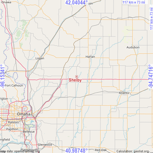
Shelby GPS coordinates[2]
41° 30' 57.96" North, 95° 27' 1.008" West
| Map corner | latitude | longitude |
|---|---|---|
| Upper-left | 42.04044°, | -96.15341° |
| Center: | 41.5161°, | -95.45028° |
| Lower-right: | 40.98748°, | -94.74716° |
| Map W x H: | 117.1×117.1 km | = 72.8×72.8mi |
| max Lat: | 71.29058° ⇑29% North |
| Shelby: | 41.5161° |
| min Lat: | ⇓71% South 19.06759° |
| min Long | Shelby | max Long |
| -171.73463° | -95.45028° | -66.98998° |
| W 27.8%⇐ | ⇒72.2% E |
Elevation
Elevation of Shelby is 396 m = 1299 ft, and this is 101.2 m = 332 ft above average elevation for this country.
| Max E: |
3189 m = 10463 ft | 16.6% |
| Shelby | 396 m 1299 ft | |
| Avg. | 294.8 m = 967 ft | |
Min E: |
-60 m = -197 ft | 83.4% |
See also: United States elevation on elevation.city.
Geographical zone
Shelby is located in North temperate zone (between Tropic of Cancer and the Arctic Circle). Distance of this Northern Tropic circle is 2010.2 km =1249.1 mi to South.| Distance of | km | miles | from Shelby |
|---|---|---|---|
| North Pole | 5390.9 | 3349.7 | to North |
| Arctic Circle | 2785 | 1730.5 | to North |
| Tropic Cancer | 2010.2 | 1249.1 | to South |
| Equator | 4616.2 | 2868.4 | to South |


Nearby cities:
15 places around Shelby: (largest is in red/bold)
• Atlantic
38.5 km =23.9 mi,  108°
108°
• Avoca
10.3 km =6.4 mi,  115°
115°
• Carson
31.2 km =19.4 mi,  175°
175°
• Crescent
37.9 km =23.5 mi,  243°
243°
• Elk Horn
33.5 km =20.8 mi,  75°
75°
• Harlan
18.4 km =11.4 mi,  34°
34°
• Logan
31.5 km =19.6 mi,  296°
296°
• Minden
9.4 km =5.8 mi,  234°
234°
• Missouri Valley
36.7 km =22.8 mi,  277°
277°
• Neola
15.7 km =9.8 mi, 241°
• Oakland
23.4 km =14.5 mi,  169°
169°
• Treynor
34.3 km =21.3 mi,  203°
203°
• Underwood
23.7 km =14.7 mi, 232°
• Walnut
19.5 km =12.1 mi,  102°
102°
• Woodbine
32.4 km =20.1 mi,  319°
319°
Sources, notices
• [Note1] Compared only with cities in United States existing in our database
• [Src1] Map data: © OpenStreetMap contributors (CC-BY-SA)
• [Src2] Other city data from geonames.org with taken over terms of usage.
• [Src3] Geographical zone / Annual Mean Temperature by Robert A. Rohde @ Wikipedia
