Bellevue geodata
Bellevue (Iowa) is a populated place; located in United States in America/Chicago (GMT-5) time zone. With population of 2,176 people, there are 11399 cities with bigger population in this country. Compared to other cities in United States, 77.8% of cities are located further ↓South; 60.6% of cities are located further →East and 52.8% of cities have higher elevation than Bellevue. Note1


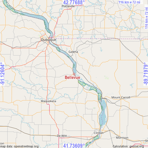
Bellevue GPS coordinates[2]
42° 15' 31.068" North, 90° 25' 22.476" West
| Map corner | latitude | longitude |
|---|---|---|
| Upper-left | 42.77688°, | -91.12604° |
| Center: | 42.25863°, | -90.42291° |
| Lower-right: | 41.73609°, | -89.71979° |
| Map W x H: | 115.7×115.7 km | = 71.9×71.9mi |
| max Lat: | 71.29058° ⇑22.2% North |
| Bellevue: | 42.25863° |
| min Lat: | ⇓77.8% South 19.06759° |
| min Long | Bellevue | max Long |
| -171.73463° | -90.42291° | -66.98998° |
| W 39.4%⇐ | ⇒60.6% E |
Elevation
Elevation of Bellevue is 188 m = 617 ft, and this is 106.8 m = 350 ft below average elevation for this country.
| Max E: |
3189 m = 10463 ft | 52.8% |
| Avg. | 294.8 m = 967 ft | |
| Bellevue | 188 m = 617 ft | |
Min E: |
-60 m = -197 ft | 47.2% |
See also: United States elevation on elevation.city.
Geographical zone
Bellevue is located in North temperate zone (between Tropic of Cancer and the Arctic Circle). Distance of this Northern Tropic circle is 2092.8 km =1300.4 mi to South.| Distance of | km | miles | from Bellevue |
|---|---|---|---|
| North Pole | 5308.3 | 3298.4 | to North |
| Arctic Circle | 2702.5 | 1679.3 | to North |
| Tropic Cancer | 2092.8 | 1300.4 | to South |
| Equator | 4698.7 | 2919.6 | to South |


Nearby cities:
15 places around Bellevue: (largest is in red/bold)
• Apple Canyon Lake
28.4 km =17.6 mi,  50°
50°
• Benton
34.8 km =21.6 mi,  5°
5°
• Delmar
32.3 km =20.1 mi,  208°
208°
• Dubuque
33.4 km =20.8 mi,  323°
323°
• East Dubuque
31.6 km =19.6 mi,  325°
325°
• Elizabeth
17.8 km =11.1 mi,  68°
68°
• Galena
17.6 km =10.9 mi,  358°
358°
• Hanover
11.8 km =7.3 mi,  91°
91°
• Hazel Green
30.5 km =19 mi, 358°
• Maquoketa
29.1 km =18.1 mi,  223°
223°
• Preston
23.2 km =14.4 mi,  178°
178°
• Sabula
29.2 km =18.1 mi,  135°
135°
• Savanna
28.5 km =17.7 mi,  129°
129°
• Stockton
35.7 km =22.2 mi, 73°
• The Galena Territory
17 km =10.6 mi,  28°
28°
Sources, notices
• [Note1] Compared only with cities in United States existing in our database
• [Src1] Map data: © OpenStreetMap contributors (CC-BY-SA)
• [Src2] Other city data from geonames.org with taken over terms of usage.
• [Src3] Geographical zone / Annual Mean Temperature by Robert A. Rohde @ Wikipedia
