Galena geodata
Galena (Illinois) is a seat of a second-order administrative division; located in United States in America/Chicago (GMT-5) time zone. With population of 3,299 people, there are 9149 cities with bigger population in this country. Compared to other cities in United States, 79% of cities are located further ↓South; 60.6% of cities are located further →East and 50.3% of cities have higher elevation than Galena. Note1
Administrative division(s):
- Level 1: Illinois
- Level 2: Jo Daviess County
- Level 3: Township of West Galena


Galena GPS coordinates[2]
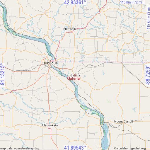
42° 25' 0.012" North, 90° 25' 44.472" West
| Map corner | latitude | longitude |
|---|---|---|
| Upper-left | 42.93361°, | -91.13215° |
| Center: | 42.41667°, | -90.42902° |
| Lower-right: | 41.89543°, | -89.7259° |
| Map W x H: | 115.4×115.4 km | = 71.7×71.7mi |
| max Lat: | 71.29058° ⇑21% North |
| Galena: | 42.41667° |
| min Lat: | ⇓79% South 19.06759° |
| min Long | Galena | max Long |
| -171.73463° | -90.42902° | -66.98998° |
| W 39.4%⇐ | ⇒60.6% E |
Elevation
Elevation of Galena is 197 m = 646 ft, and this is 97.8 m = 321 ft below average elevation for this country.
| Max E: |
3189 m = 10463 ft | 50.3% |
| Avg. | 294.8 m = 967 ft | |
| Galena | 197 m = 646 ft | |
Min E: |
-60 m = -197 ft | 49.7% |
See also: United States elevation on elevation.city.
Geographical zone
Galena is located in North temperate zone (between Tropic of Cancer and the Arctic Circle). Distance of this Northern Tropic circle is 2110.4 km =1311.3 mi to South.| Distance of | km | miles | from Galena |
|---|---|---|---|
| North Pole | 5290.8 | 3287.5 | to North |
| Arctic Circle | 2684.9 | 1668.3 | to North |
| Tropic Cancer | 2110.4 | 1311.3 | to South |
| Equator | 4716.3 | 2930.6 | to South |


Nearby cities:
15 places around Galena: (largest is in red/bold)
• Apple Canyon Lake
22.4 km =13.9 mi,  88°
88°
• Asbury
28.6 km =17.8 mi,  292°
292°
• Bellevue
17.6 km =10.9 mi,  178°
178°
• Benton
17.5 km =10.9 mi,  13°
13°
• Cuba City
21 km =13 mi,  359°
359°
• Dickeyville
27 km =16.8 mi,  330°
330°
• Dubuque
21.5 km =13.4 mi,  295°
295°
• East Dubuque
19.5 km =12.1 mi, 295°
• Elizabeth
20.3 km =12.6 mi,  122°
122°
• Hanover
21.6 km =13.4 mi,  145°
145°
• Hazel Green
12.9 km =8 mi, 357°
• Peosta
34.8 km =21.6 mi,  276°
276°
• Shullsburg
23.8 km =14.8 mi,  42°
42°
• Stockton
35.5 km =22.1 mi,  102°
102°
• The Galena Territory
8.9 km =5.5 mi,  106°
106°
Sources, notices
• [Note1] Compared only with cities in United States existing in our database
• [Src1] Map data: © OpenStreetMap contributors (CC-BY-SA)
• [Src2] Other city data from geonames.org with taken over terms of usage.
• [Src3] Geographical zone / Annual Mean Temperature by Robert A. Rohde @ Wikipedia
