Dubuque geodata
Dubuque (Iowa) is a seat of a second-order administrative division; located in United States in America/Chicago (GMT-5) time zone. With population of 58,799 people, there are 770 cities with bigger population in this country. Compared to other cities in United States, 79.8% of cities are located further ↓South; 61.4% of cities are located further →East and 51.1% of cities have higher elevation than Dubuque. Note1


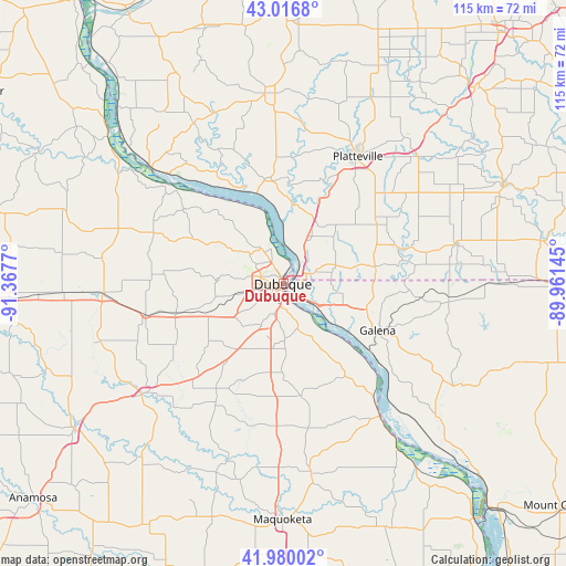
Dubuque GPS coordinates[2]
42° 30' 2.016" North, 90° 39' 52.452" West
| Map corner | latitude | longitude |
|---|---|---|
| Upper-left | 43.0168°, | -91.3677° |
| Center: | 42.50056°, | -90.66457° |
| Lower-right: | 41.98002°, | -89.96145° |
| Map W x H: | 115.3×115.3 km | = 71.6×71.6mi |
| max Lat: | 71.29058° ⇑20.2% North |
| Dubuque: | 42.50056° |
| min Lat: | ⇓79.8% South 19.06759° |
| min Long | Dubuque | max Long |
| -171.73463° | -90.66457° | -66.98998° |
| W 38.6%⇐ | ⇒61.4% E |
Elevation
Elevation of Dubuque is 194 m = 636 ft, and this is 100.8 m = 331 ft below average elevation for this country.
| Max E: |
3189 m = 10463 ft | 51.1% |
| Avg. | 294.8 m = 967 ft | |
| Dubuque | 194 m = 636 ft | |
Min E: |
-60 m = -197 ft | 48.9% |
See also: Dubuque elevation on elevation.city.
Geographical zone
Dubuque is located in North temperate zone (between Tropic of Cancer and the Arctic Circle). Distance of this Northern Tropic circle is 2119.7 km =1317.1 mi to South.| Distance of | km | miles | from Dubuque |
|---|---|---|---|
| North Pole | 5281.4 | 3281.7 | to North |
| Arctic Circle | 2675.6 | 1662.5 | to North |
| Tropic Cancer | 2119.7 | 1317.1 | to South |
| Equator | 4725.6 | 2936.4 | to South |


Nearby cities:
15 places around Dubuque: (largest is in red/bold)
• Asbury
7.3 km =4.5 mi,  282°
282°
• Bellevue
33.4 km =20.8 mi,  143°
143°
• Benton
24.5 km =15.2 mi,  71°
71°
• Cassville
35.7 km =22.2 mi,  311°
311°
• Cuba City
22.5 km =14 mi,  58°
58°
• Dickeyville
15.3 km =9.5 mi,  22°
22°
• East Dubuque
2 km =1.2 mi,  117°
117°
• Epworth
22.8 km =14.2 mi,  254°
254°
• Farley
28.7 km =17.8 mi,  257°
257°
• Galena
21.5 km =13.4 mi, 115°
• Hazel Green
19.2 km =11.9 mi,  79°
79°
• Peosta
16.2 km =10.1 mi, 249°
• Platteville
30.1 km =18.7 mi,  30°
30°
• Potosi
21.4 km =13.3 mi,  349°
349°
• The Galena Territory
30.2 km =18.8 mi,  113°
113°
Sources, notices
• [Note1] Compared only with cities in United States existing in our database
• [Src1] Map data: © OpenStreetMap contributors (CC-BY-SA)
• [Src2] Other city data from geonames.org with taken over terms of usage.
• [Src3] Geographical zone / Annual Mean Temperature by Robert A. Rohde @ Wikipedia
