Forest City geodata
Forest City (Iowa) is a seat of a second-order administrative division; located in United States in America/Chicago (GMT-5) time zone. With population of 4,018 people, there are 8196 cities with bigger population in this country. Compared to other cities in United States, 85.2% of cities are located further ↓South; 67.9% of cities are located further →East and 82.7% of cities have lower elevation than Forest City. Note1


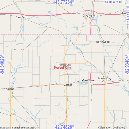
Forest City GPS coordinates[2]
43° 15' 44.856" North, 93° 38' 13.776" West
| Map corner | latitude | longitude |
|---|---|---|
| Upper-left | 43.77234°, | -94.34029° |
| Center: | 43.26246°, | -93.63716° |
| Lower-right: | 42.74828°, | -92.93404° |
| Map W x H: | 113.9×113.9 km | = 70.8×70.8mi |
| max Lat: | 71.29058° ⇑14.8% North |
| Forest City: | 43.26246° |
| min Lat: | ⇓85.2% South 19.06759° |
| min Long | Forest City | max Long |
| -171.73463° | -93.63716° | -66.98998° |
| W 32.1%⇐ | ⇒67.9% E |
Elevation
Elevation of Forest City is 386 m = 1266 ft, and this is 91.2 m = 299 ft above average elevation for this country.
| Max E: |
3189 m = 10463 ft | 17.3% |
| Forest City | 386 m 1266 ft | |
| Avg. | 294.8 m = 967 ft | |
Min E: |
-60 m = -197 ft | 82.7% |
See also: United States elevation on elevation.city.
Geographical zone
Forest City is located in North temperate zone (between Tropic of Cancer and the Arctic Circle). Distance of this Northern Tropic circle is 2204.4 km =1369.8 mi to South.| Distance of | km | miles | from Forest City |
|---|---|---|---|
| North Pole | 5196.7 | 3229.1 | to North |
| Arctic Circle | 2590.8 | 1609.8 | to North |
| Tropic Cancer | 2204.4 | 1369.8 | to South |
| Equator | 4810.3 | 2989 | to South |


Nearby cities:
15 places around Forest City: (largest is in red/bold)
• Alden
45.6 km =28.3 mi,  6°
6°
• Bancroft
47.1 km =29.3 mi,  274°
274°
• Belmond
46.3 km =28.8 mi,  177°
177°
• Britt
22.7 km =14.1 mi,  216°
216°
• Buffalo Center
28.5 km =17.7 mi,  298°
298°
• Clear Lake
25.1 km =15.6 mi,  123°
123°
• Elmore
45.3 km =28.1 mi,  306°
306°
• Garner
18 km =11.2 mi,  170°
170°
• Glenville
44.9 km =27.9 mi,  39°
39°
• Kanawha
38.3 km =23.8 mi,  199°
199°
• Lake Mills
19.4 km =12.1 mi,  25°
25°
• Manly
35.3 km =21.9 mi,  85°
85°
• Mason City
37.4 km =23.2 mi,  108°
108°
• Northwood
39.2 km =24.4 mi,  59°
59°
• Ventura
19.9 km =12.4 mi,  139°
139°
Sources, notices
• [Note1] Compared only with cities in United States existing in our database
• [Src1] Map data: © OpenStreetMap contributors (CC-BY-SA)
• [Src2] Other city data from geonames.org with taken over terms of usage.
• [Src3] Geographical zone / Annual Mean Temperature by Robert A. Rohde @ Wikipedia
