Glenville geodata
Glenville (Minnesota) is a populated place; located in United States in America/Chicago (GMT-5) time zone. With population of 630 people, there are 19355 cities with bigger population in this country. Compared to other cities in United States, 86.6% of cities are located further ↓South; 67% of cities are located further →East and 82% of cities have lower elevation than Glenville. Note1


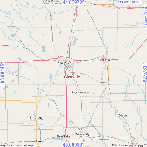
Glenville GPS coordinates[2]
43° 34' 20.856" North, 93° 16' 52.752" West
| Map corner | latitude | longitude |
|---|---|---|
| Upper-left | 44.07972°, | -93.98445° |
| Center: | 43.57246°, | -93.28132° |
| Lower-right: | 43.06089°, | -92.5782° |
| Map W x H: | 113.3×113.3 km | = 70.4×70.4mi |
| max Lat: | 71.29058° ⇑13.4% North |
| Glenville: | 43.57246° |
| min Lat: | ⇓86.6% South 19.06759° |
| min Long | Glenville | max Long |
| -171.73463° | -93.28132° | -66.98998° |
| W 33%⇐ | ⇒67% E |
Elevation
Elevation of Glenville is 376 m = 1234 ft, and this is 81.2 m = 266 ft above average elevation for this country.
| Max E: |
3189 m = 10463 ft | 18% |
| Glenville | 376 m 1234 ft | |
| Avg. | 294.8 m = 967 ft | |
Min E: |
-60 m = -197 ft | 82% |
See also: United States elevation on elevation.city.
Geographical zone
Glenville is located in North temperate zone (between Tropic of Cancer and the Arctic Circle). Distance of this Northern Tropic circle is 2238.9 km =1391.2 mi to South.| Distance of | km | miles | from Glenville |
|---|---|---|---|
| North Pole | 5162.3 | 3207.7 | to North |
| Arctic Circle | 2556.4 | 1588.5 | to North |
| Tropic Cancer | 2238.9 | 1391.2 | to South |
| Equator | 4844.8 | 3010.4 | to South |


Nearby cities:
15 places around Glenville: (largest is in red/bold)
• Albert Lea
10.9 km =6.8 mi,  320°
320°
• Alden
26.1 km =16.2 mi,  294°
294°
• Austin
26.8 km =16.7 mi,  67°
67°
• Blooming Prairie
37.6 km =23.4 mi,  29°
29°
• Brownsdale
38 km =23.6 mi,  60°
60°
• Clarks Grove
21.6 km =13.4 mi,  349°
349°
• Ellendale
33.4 km =20.8 mi,  357°
357°
• Geneva
27.9 km =17.3 mi,  2°
2°
• Lake Mills
26.5 km =16.5 mi,  230°
230°
• Lyle
28.2 km =17.5 mi,  105°
105°
• Manly
32.4 km =20.1 mi,  168°
168°
• New Richland
39.6 km =24.6 mi,  334°
334°
• Northwood
15.1 km =9.4 mi,  161°
161°
• Saint Ansgar
36.4 km =22.6 mi,  126°
126°
• Wells
40.8 km =25.4 mi,  298°
298°
Sources, notices
• [Note1] Compared only with cities in United States existing in our database
• [Src1] Map data: © OpenStreetMap contributors (CC-BY-SA)
• [Src2] Other city data from geonames.org with taken over terms of usage.
• [Src3] Geographical zone / Annual Mean Temperature by Robert A. Rohde @ Wikipedia
