Lake Mills geodata
Lake Mills (Iowa) is a populated place; located in United States in America/Chicago (GMT-5) time zone. With population of 2,060 people, there are 11757 cities with bigger population in this country. Compared to other cities in United States, 86% of cities are located further ↓South; 67.6% of cities are located further →East and 83.1% of cities have lower elevation than Lake Mills. Note1


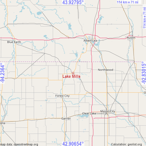
Lake Mills GPS coordinates[2]
43° 25' 9.84" North, 93° 31' 59.772" West
| Map corner | latitude | longitude |
|---|---|---|
| Upper-left | 43.92795°, | -94.2364° |
| Center: | 43.4194°, | -93.53327° |
| Lower-right: | 42.90654°, | -92.83015° |
| Map W x H: | 113.6×113.6 km | = 70.6×70.6mi |
| max Lat: | 71.29058° ⇑14% North |
| Lake Mills: | 43.4194° |
| min Lat: | ⇓86% South 19.06759° |
| min Long | Lake Mills | max Long |
| -171.73463° | -93.53327° | -66.98998° |
| W 32.4%⇐ | ⇒67.6% E |
Elevation
Elevation of Lake Mills is 392 m = 1286 ft, and this is 97.2 m = 319 ft above average elevation for this country.
| Max E: |
3189 m = 10463 ft | 16.9% |
| Lake Mills | 392 m 1286 ft | |
| Avg. | 294.8 m = 967 ft | |
Min E: |
-60 m = -197 ft | 83.1% |
See also: United States elevation on elevation.city.
Geographical zone
Lake Mills is located in North temperate zone (between Tropic of Cancer and the Arctic Circle). Distance of this Northern Tropic circle is 2221.9 km =1380.6 mi to South.| Distance of | km | miles | from Lake Mills |
|---|---|---|---|
| North Pole | 5179.3 | 3218.3 | to North |
| Arctic Circle | 2573.4 | 1599 | to North |
| Tropic Cancer | 2221.9 | 1380.6 | to South |
| Equator | 4827.8 | 2999.9 | to South |


Nearby cities:
15 places around Lake Mills: (largest is in red/bold)
• Albert Lea
28.7 km =17.8 mi,  27°
27°
• Alden
28.1 km =17.5 mi,  352°
352°
• Britt
41.9 km =26 mi,  211°
211°
• Buffalo Center
33.6 km =20.9 mi,  263°
263°
• Clarks Grove
41.7 km =25.9 mi,  23°
23°
• Clear Lake
33.7 km =20.9 mi,  158°
158°
• Elmore
45.8 km =28.5 mi,  281°
281°
• Forest City
19.4 km =12.1 mi, 205°
• Garner
35.7 km =22.2 mi,  188°
188°
• Glenville
26.5 km =16.5 mi,  50°
50°
• Manly
30.5 km =19 mi,  118°
118°
• Mason City
40 km =24.9 mi,  137°
137°
• Northwood
25.4 km =15.8 mi,  83°
83°
• Ventura
32.9 km =20.4 mi,  172°
172°
• Wells
39.6 km =24.6 mi,  336°
336°
Sources, notices
• [Note1] Compared only with cities in United States existing in our database
• [Src1] Map data: © OpenStreetMap contributors (CC-BY-SA)
• [Src2] Other city data from geonames.org with taken over terms of usage.
• [Src3] Geographical zone / Annual Mean Temperature by Robert A. Rohde @ Wikipedia
