Keota geodata
Keota (Iowa) is a populated place; located in United States in America/Chicago (GMT-5) time zone. With population of 970 people, there are 16492 cities with bigger population in this country. Compared to other cities in United States, 69.5% of cities are located further ↓South; 64% of cities are located further →East and 60.7% of cities have lower elevation than Keota. Note1


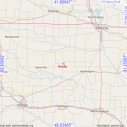
Keota GPS coordinates[2]
41° 21' 50.04" North, 91° 57' 13.644" West
| Map corner | latitude | longitude |
|---|---|---|
| Upper-left | 41.88947°, | -92.65692° |
| Center: | 41.3639°, | -91.95379° |
| Lower-right: | 40.83405°, | -91.25067° |
| Map W x H: | 117.4×117.4 km | = 72.9×72.9mi |
| max Lat: | 71.29058° ⇑30.5% North |
| Keota: | 41.3639° |
| min Lat: | ⇓69.5% South 19.06759° |
| min Long | Keota | max Long |
| -171.73463° | -91.95379° | -66.98998° |
| W 36%⇐ | ⇒64% E |
Elevation
Elevation of Keota is 243 m = 797 ft, and this is 51.8 m = 170 ft below average elevation for this country.
| Max E: |
3189 m = 10463 ft | 39.3% |
| Avg. | 294.8 m = 967 ft | |
| Keota | 243 m = 797 ft | |
Min E: |
-60 m = -197 ft | 60.7% |
See also: United States elevation on elevation.city.
Geographical zone
Keota is located in North temperate zone (between Tropic of Cancer and the Arctic Circle). Distance of this Northern Tropic circle is 1993.3 km =1238.6 mi to South.| Distance of | km | miles | from Keota |
|---|---|---|---|
| North Pole | 5407.8 | 3360.3 | to North |
| Arctic Circle | 2801.9 | 1741 | to North |
| Tropic Cancer | 1993.3 | 1238.6 | to South |
| Equator | 4599.2 | 2857.8 | to South |


Nearby cities:
15 places around Keota: (largest is in red/bold)
• Ainsworth
34.5 km =21.4 mi,  103°
103°
• Brighton
23.8 km =14.8 mi,  151°
151°
• Fairfield
39.5 km =24.5 mi,  181°
181°
• Hedrick
36.5 km =22.7 mi,  234°
234°
• Kalona
24.5 km =15.2 mi,  57°
57°
• Maharishi Vedic City
34.8 km =21.6 mi,  185°
185°
• North English
19.6 km =12.2 mi,  328°
328°
• Richland
20.1 km =12.5 mi, 189°
• Riverside
33.6 km =20.9 mi,  67°
67°
• Sigourney
21.2 km =13.2 mi,  260°
260°
• Washington
22.9 km =14.2 mi,  108°
108°
• Wayland
34.4 km =21.4 mi,  134°
134°
• Wellman
14.7 km =9.1 mi,  40°
40°
• What Cheer
33.7 km =20.9 mi,  277°
277°
• Williamsburg
33.4 km =20.8 mi,  352°
352°
Sources, notices
• [Note1] Compared only with cities in United States existing in our database
• [Src1] Map data: © OpenStreetMap contributors (CC-BY-SA)
• [Src2] Other city data from geonames.org with taken over terms of usage.
• [Src3] Geographical zone / Annual Mean Temperature by Robert A. Rohde @ Wikipedia
