Ainsworth geodata
Ainsworth (Iowa) is a populated place; located in United States in America/Chicago (GMT-5) time zone. With population of 571 people, there are 20023 cities with bigger population in this country. Compared to other cities in United States, 68.7% of cities are located further ↓South; 63.2% of cities are located further →East and 55.1% of cities have lower elevation than Ainsworth. Note1


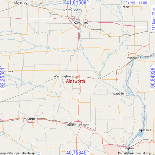
Ainsworth GPS coordinates[2]
41° 17' 20.076" North, 91° 33' 8.568" West
| Map corner | latitude | longitude |
|---|---|---|
| Upper-left | 41.81509°, | -92.25551° |
| Center: | 41.28891°, | -91.55238° |
| Lower-right: | 40.75845°, | -90.84926° |
| Map W x H: | 117.5×117.5 km | = 73×73mi |
| max Lat: | 71.29058° ⇑31.3% North |
| Ainsworth: | 41.28891° |
| min Lat: | ⇓68.7% South 19.06759° |
| min Long | Ainsworth | max Long |
| -171.73463° | -91.55238° | -66.98998° |
| W 36.8%⇐ | ⇒63.2% E |
Elevation
Elevation of Ainsworth is 219 m = 719 ft, and this is 75.8 m = 249 ft below average elevation for this country.
| Max E: |
3189 m = 10463 ft | 44.9% |
| Avg. | 294.8 m = 967 ft | |
| Ainsworth | 219 m = 719 ft | |
Min E: |
-60 m = -197 ft | 55.1% |
See also: United States elevation on elevation.city.
Geographical zone
Ainsworth is located in North temperate zone (between Tropic of Cancer and the Arctic Circle). Distance of this Northern Tropic circle is 1985 km =1233.4 mi to South.| Distance of | km | miles | from Ainsworth |
|---|---|---|---|
| North Pole | 5416.2 | 3365.5 | to North |
| Arctic Circle | 2810.3 | 1746.2 | to North |
| Tropic Cancer | 1985 | 1233.4 | to South |
| Equator | 4590.9 | 2852.7 | to South |


Nearby cities:
15 places around Ainsworth: (largest is in red/bold)
• Brighton
25.7 km =16 mi,  240°
240°
• Columbus Junction
16 km =9.9 mi,  93°
93°
• Fruitland
36.1 km =22.4 mi,  78°
78°
• Grandview
30.4 km =18.9 mi, 92°
• Hills
29.5 km =18.3 mi,  2°
2°
• Kalona
25.1 km =15.6 mi,  329°
329°
• Keota
34.5 km =21.4 mi,  283°
283°
• Lone Tree
24.5 km =15.2 mi,  25°
25°
• Morning Sun
32.7 km =20.3 mi,  130°
130°
• Riverside
21.4 km =13.3 mi,  353°
353°
• Wapello
32.9 km =20.4 mi,  111°
111°
• Washington
11.8 km =7.3 mi, 275°
• Wayland
18.2 km =11.3 mi,  209°
209°
• Wellman
30.8 km =19.1 mi,  309°
309°
• Winfield
20.6 km =12.8 mi,  153°
153°
Sources, notices
• [Note1] Compared only with cities in United States existing in our database
• [Src1] Map data: © OpenStreetMap contributors (CC-BY-SA)
• [Src2] Other city data from geonames.org with taken over terms of usage.
• [Src3] Geographical zone / Annual Mean Temperature by Robert A. Rohde @ Wikipedia
