Washington geodata
Washington (Iowa) is a seat of a second-order administrative division; located in United States in America/Chicago (GMT-5) time zone. With population of 7,408 people, there are 5586 cities with bigger population in this country. Compared to other cities in United States, 68.8% of cities are located further ↓South; 63.5% of cities are located further →East and 58.8% of cities have lower elevation than Washington. Note1
Administrative division(s):
- Level 1: Iowa
- Level 2: Washington County
- Level 3: Township of Washington


Washington GPS coordinates[2]
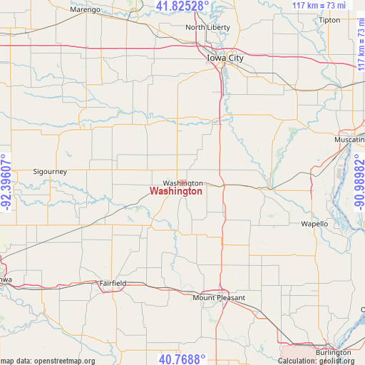
41° 17' 57.048" North, 91° 41' 34.584" West
| Map corner | latitude | longitude |
|---|---|---|
| Upper-left | 41.82528°, | -92.39607° |
| Center: | 41.29918°, | -91.69294° |
| Lower-right: | 40.7688°, | -90.98982° |
| Map W x H: | 117.5×117.5 km | = 73×73mi |
| max Lat: | 71.29058° ⇑31.2% North |
| Washington: | 41.29918° |
| min Lat: | ⇓68.8% South 19.06759° |
| min Long | Washington | max Long |
| -171.73463° | -91.69294° | -66.98998° |
| W 36.5%⇐ | ⇒63.5% E |
Elevation
Elevation of Washington is 234 m = 768 ft, and this is 60.8 m = 199 ft below average elevation for this country.
| Max E: |
3189 m = 10463 ft | 41.2% |
| Avg. | 294.8 m = 967 ft | |
| Washington | 234 m = 768 ft | |
Min E: |
-60 m = -197 ft | 58.8% |
See also: United States elevation on elevation.city.
Geographical zone
Washington is located in North temperate zone (between Tropic of Cancer and the Arctic Circle). Distance of this Northern Tropic circle is 1986.1 km =1234.1 mi to South.| Distance of | km | miles | from Washington |
|---|---|---|---|
| North Pole | 5415 | 3364.7 | to North |
| Arctic Circle | 2809.1 | 1745.5 | to North |
| Tropic Cancer | 1986.1 | 1234.1 | to South |
| Equator | 4592 | 2853.3 | to South |


Nearby cities:
15 places around Washington: (largest is in red/bold)
• Ainsworth
11.8 km =7.3 mi,  95°
95°
• Brighton
17.4 km =10.8 mi,  217°
217°
• Columbus Junction
27.8 km =17.3 mi,  94°
94°
• Fairfield
39.4 km =24.5 mi,  214°
214°
• Hills
31.3 km =19.4 mi,  24°
24°
• Kalona
20.5 km =12.7 mi,  356°
356°
• Keota
22.9 km =14.2 mi,  288°
288°
• Lone Tree
30.6 km =19 mi,  46°
46°
• Maharishi Vedic City
37.3 km =23.2 mi, 222°
• Mount Pleasant
39 km =24.2 mi,  163°
163°
• Richland
28.1 km =17.5 mi,  243°
243°
• Riverside
22.1 km =13.7 mi, 24°
• Wayland
17.1 km =10.6 mi,  170°
170°
• Wellman
22 km =13.7 mi,  326°
326°
• Winfield
28.7 km =17.8 mi,  132°
132°
Sources, notices
• [Note1] Compared only with cities in United States existing in our database
• [Src1] Map data: © OpenStreetMap contributors (CC-BY-SA)
• [Src2] Other city data from geonames.org with taken over terms of usage.
• [Src3] Geographical zone / Annual Mean Temperature by Robert A. Rohde @ Wikipedia
