Manchester geodata
Manchester (Iowa) is a seat of a second-order administrative division; located in United States in America/Chicago (GMT-5) time zone. With population of 5,073 people, there are 7105 cities with bigger population in this country. Compared to other cities in United States, 79.7% of cities are located further ↓South; 63% of cities are located further →East and 70.6% of cities have lower elevation than Manchester. Note1


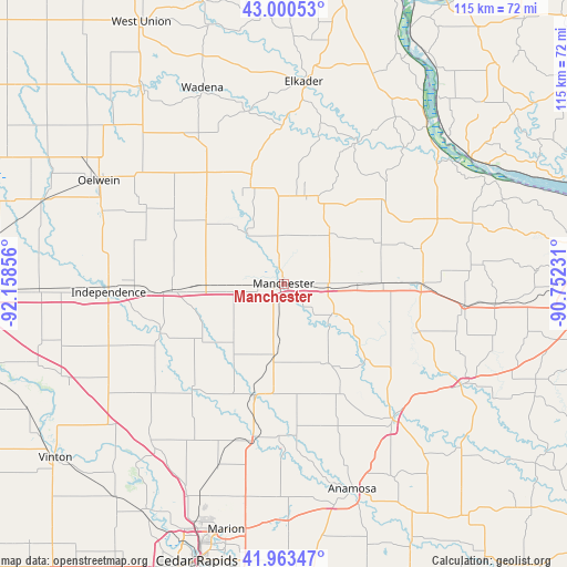
Manchester GPS coordinates[2]
42° 29' 2.94" North, 91° 27' 19.548" West
| Map corner | latitude | longitude |
|---|---|---|
| Upper-left | 43.00053°, | -92.15856° |
| Center: | 42.48415°, | -91.45543° |
| Lower-right: | 41.96347°, | -90.75231° |
| Map W x H: | 115.3×115.3 km | = 71.6×71.6mi |
| max Lat: | 71.29058° ⇑20.3% North |
| Manchester: | 42.48415° |
| min Lat: | ⇓79.7% South 19.06759° |
| min Long | Manchester | max Long |
| -171.73463° | -91.45543° | -66.98998° |
| W 37%⇐ | ⇒63% E |
Elevation
Elevation of Manchester is 289 m = 948 ft, and this is 5.8 m = 19 ft below average elevation for this country.
| Max E: |
3189 m = 10463 ft | 29.4% |
| Avg. | 294.8 m = 967 ft | |
| Manchester | 289 m = 948 ft | |
Min E: |
-60 m = -197 ft | 70.6% |
See also: United States elevation on elevation.city.
Geographical zone
Manchester is located in North temperate zone (between Tropic of Cancer and the Arctic Circle). Distance of this Northern Tropic circle is 2117.9 km =1316 mi to South.| Distance of | km | miles | from Manchester |
|---|---|---|---|
| North Pole | 5283.3 | 3282.9 | to North |
| Arctic Circle | 2677.4 | 1663.7 | to North |
| Tropic Cancer | 2117.9 | 1316 | to South |
| Equator | 4723.8 | 2935.2 | to South |


Nearby cities:
15 places around Manchester: (largest is in red/bold)
• Alburnett
39.7 km =24.7 mi,  199°
199°
• Central City
31.7 km =19.7 mi,  190°
190°
• Coggon
23.4 km =14.5 mi, 195°
• Dyersville
27.3 km =17 mi,  89°
89°
• Earlville
15 km =9.3 mi, 91°
• Edgewood
18.4 km =11.4 mi,  13°
13°
• Farley
37.1 km =23.1 mi,  97°
97°
• Hazleton
39.5 km =24.5 mi,  292°
292°
• Hopkinton
23.1 km =14.4 mi,  132°
132°
• Independence
35.6 km =22.1 mi,  267°
267°
• Monticello
35.1 km =21.8 mi,  141°
141°
• Quasqueton
27 km =16.8 mi,  248°
248°
• Strawberry Point
23.1 km =14.4 mi,  343°
343°
• Walker
34.6 km =21.5 mi,  230°
230°
• Winthrop
22.9 km =14.2 mi, 266°
Sources, notices
• [Note1] Compared only with cities in United States existing in our database
• [Src1] Map data: © OpenStreetMap contributors (CC-BY-SA)
• [Src2] Other city data from geonames.org with taken over terms of usage.
• [Src3] Geographical zone / Annual Mean Temperature by Robert A. Rohde @ Wikipedia
