Independence geodata
Independence (Iowa) is a seat of a second-order administrative division; located in United States in America/Chicago (GMT-5) time zone. With population of 6,028 people, there are 6388 cities with bigger population in this country. Compared to other cities in United States, 79.5% of cities are located further ↓South; 63.9% of cities are located further →East and 69.9% of cities have lower elevation than Independence. Note1


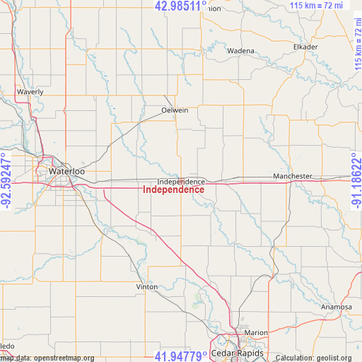
Independence GPS coordinates[2]
42° 28' 6.96" North, 91° 53' 21.624" West
| Map corner | latitude | longitude |
|---|---|---|
| Upper-left | 42.98511°, | -92.59247° |
| Center: | 42.4686°, | -91.88934° |
| Lower-right: | 41.94779°, | -91.18622° |
| Map W x H: | 115.3×115.3 km | = 71.6×71.6mi |
| max Lat: | 71.29058° ⇑20.5% North |
| Independence: | 42.4686° |
| min Lat: | ⇓79.5% South 19.06759° |
| min Long | Independence | max Long |
| -171.73463° | -91.88934° | -66.98998° |
| W 36.1%⇐ | ⇒63.9% E |
Elevation
Elevation of Independence is 285 m = 935 ft, and this is 9.8 m = 32 ft below average elevation for this country.
| Max E: |
3189 m = 10463 ft | 30.1% |
| Avg. | 294.8 m = 967 ft | |
| Independence | 285 m = 935 ft | |
Min E: |
-60 m = -197 ft | 69.9% |
See also: United States elevation on elevation.city.
Geographical zone
Independence is located in North temperate zone (between Tropic of Cancer and the Arctic Circle). Distance of this Northern Tropic circle is 2116.1 km =1314.9 mi to South.| Distance of | km | miles | from Independence |
|---|---|---|---|
| North Pole | 5285 | 3283.9 | to North |
| Arctic Circle | 2679.1 | 1664.7 | to North |
| Tropic Cancer | 2116.1 | 1314.9 | to South |
| Equator | 4722.1 | 2934.2 | to South |


Nearby cities:
15 places around Independence: (largest is in red/bold)
• Center Point
32 km =19.9 mi,  164°
164°
• Dunkerton
24.9 km =15.5 mi,  296°
296°
• Elk Run Heights
30.1 km =18.7 mi,  269°
269°
• Fairbank
22.9 km =14.2 mi,  325°
325°
• Gilbertville
27.3 km =17 mi,  257°
257°
• Hazleton
16.9 km =10.5 mi,  356°
356°
• Jesup
14.3 km =8.9 mi, 273°
• La Porte City
30.2 km =18.8 mi,  235°
235°
• Oelwein
22.8 km =14.2 mi, 355°
• Quasqueton
13.4 km =8.3 mi,  128°
128°
• Raymond
27.1 km =16.8 mi, 270°
• Urbana
27.2 km =16.9 mi,  177°
177°
• Walker
22.1 km =13.7 mi, 156°
• Washburn
31.7 km =19.7 mi, 258°
• Winthrop
12.7 km =7.9 mi,  87°
87°
Sources, notices
• [Note1] Compared only with cities in United States existing in our database
• [Src1] Map data: © OpenStreetMap contributors (CC-BY-SA)
• [Src2] Other city data from geonames.org with taken over terms of usage.
• [Src3] Geographical zone / Annual Mean Temperature by Robert A. Rohde @ Wikipedia
