Hazleton geodata
Hazleton (Iowa) is a populated place; located in United States in America/Chicago (GMT-5) time zone. With population of 818 people, there are 17642 cities with bigger population in this country. Compared to other cities in United States, 80.7% of cities are located further ↓South; 63.9% of cities are located further →East and 73.8% of cities have lower elevation than Hazleton. Note1


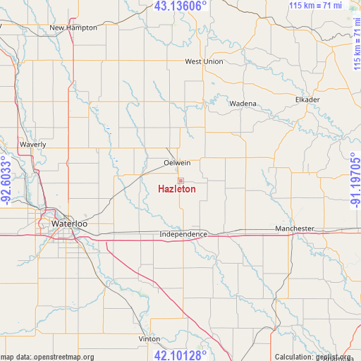
Hazleton GPS coordinates[2]
42° 37' 14.952" North, 91° 54' 0.612" West
| Map corner | latitude | longitude |
|---|---|---|
| Upper-left | 43.13606°, | -92.6033° |
| Center: | 42.62082°, | -91.90017° |
| Lower-right: | 42.10128°, | -91.19705° |
| Map W x H: | 115.1×115.1 km | = 71.5×71.5mi |
| max Lat: | 71.29058° ⇑19.3% North |
| Hazleton: | 42.62082° |
| min Lat: | ⇓80.7% South 19.06759° |
| min Long | Hazleton | max Long |
| -171.73463° | -91.90017° | -66.98998° |
| W 36.1%⇐ | ⇒63.9% E |
Elevation
Elevation of Hazleton is 306 m = 1004 ft, and this is 11.2 m = 37 ft above average elevation for this country.
| Max E: |
3189 m = 10463 ft | 26.2% |
| Hazleton | 306 m 1004 ft | |
| Avg. | 294.8 m = 967 ft | |
Min E: |
-60 m = -197 ft | 73.8% |
See also: United States elevation on elevation.city.
Geographical zone
Hazleton is located in North temperate zone (between Tropic of Cancer and the Arctic Circle). Distance of this Northern Tropic circle is 2133.1 km =1325.4 mi to South.| Distance of | km | miles | from Hazleton |
|---|---|---|---|
| North Pole | 5268.1 | 3273.4 | to North |
| Arctic Circle | 2662.2 | 1654.2 | to North |
| Tropic Cancer | 2133.1 | 1325.4 | to South |
| Equator | 4739 | 2944.7 | to South |


Nearby cities:
15 places around Hazleton: (largest is in red/bold)
• Dunkerton
22 km =13.7 mi,  255°
255°
• Elk Run Heights
33.8 km =21 mi,  239°
239°
• Evansdale
35.5 km =22.1 mi, 241°
• Fairbank
12.2 km =7.6 mi,  279°
279°
• Fayette
25.9 km =16.1 mi,  18°
18°
• Gilbertville
34.4 km =21.4 mi,  228°
228°
• Independence
16.9 km =10.5 mi,  176°
176°
• Jesup
21 km =13 mi,  219°
219°
• Oelwein
5.9 km =3.7 mi,  349°
349°
• Quasqueton
27.6 km =17.1 mi,  155°
155°
• Raymond
31.1 km =19.3 mi, 237°
• Readlyn
28.1 km =17.5 mi,  288°
288°
• Strawberry Point
30.7 km =19.1 mi,  76°
76°
• Sumner
29.7 km =18.5 mi,  328°
328°
• Winthrop
21.3 km =13.2 mi,  140°
140°
Sources, notices
• [Note1] Compared only with cities in United States existing in our database
• [Src1] Map data: © OpenStreetMap contributors (CC-BY-SA)
• [Src2] Other city data from geonames.org with taken over terms of usage.
• [Src3] Geographical zone / Annual Mean Temperature by Robert A. Rohde @ Wikipedia
