Muscatine geodata
Muscatine (Iowa) is a seat of a second-order administrative division; located in United States in America/Chicago (GMT-5) time zone. With population of 23,968 people, there are 2107 cities with bigger population in this country. Compared to other cities in United States, 70% of cities are located further ↓South; 62.2% of cities are located further →East and 55.5% of cities have higher elevation than Muscatine. Note1
Administrative division(s):
- Level 1: Iowa
- Level 2: Muscatine County
- Level 3: Township of Bloomington


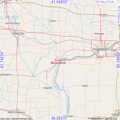
Muscatine GPS coordinates[2]
41° 25' 28.092" North, 91° 2' 35.556" West
| Map corner | latitude | longitude |
|---|---|---|
| Upper-left | 41.94955°, | -91.74634° |
| Center: | 41.42447°, | -91.04321° |
| Lower-right: | 40.89511°, | -90.34009° |
| Map W x H: | 117.2×117.2 km | = 72.8×72.8mi |
| max Lat: | 71.29058° ⇑30% North |
| Muscatine: | 41.42447° |
| min Lat: | ⇓70% South 19.06759° |
| min Long | Muscatine | max Long |
| -171.73463° | -91.04321° | -66.98998° |
| W 37.8%⇐ | ⇒62.2% E |
Elevation
Elevation of Muscatine is 178 m = 584 ft, and this is 116.8 m = 383 ft below average elevation for this country.
| Max E: |
3189 m = 10463 ft | 55.5% |
| Avg. | 294.8 m = 967 ft | |
| Muscatine | 178 m = 584 ft | |
Min E: |
-60 m = -197 ft | 44.5% |
See also: United States elevation on elevation.city.
Geographical zone
Muscatine is located in North temperate zone (between Tropic of Cancer and the Arctic Circle). Distance of this Northern Tropic circle is 2000.1 km =1242.8 mi to South.| Distance of | km | miles | from Muscatine |
|---|---|---|---|
| North Pole | 5401.1 | 3356.1 | to North |
| Arctic Circle | 2795.2 | 1736.9 | to North |
| Tropic Cancer | 2000.1 | 1242.8 | to South |
| Equator | 4606 | 2862 | to South |


Nearby cities:
15 places around Muscatine: (largest is in red/bold)
• Aledo
35 km =21.7 mi,  135°
135°
• Andalusia
27.2 km =16.9 mi,  86°
86°
• Blue Grass
24.9 km =15.5 mi,  67°
67°
• Buffalo
26.9 km =16.7 mi,  82°
82°
• Columbus Junction
31 km =19.3 mi,  238°
238°
• Durant
22.4 km =13.9 mi,  29°
29°
• Fruitland
10.5 km =6.5 mi,  223°
223°
• Grandview
20.5 km =12.7 mi, 216°
• Lone Tree
32.7 km =20.3 mi,  282°
282°
• New Boston
28.5 km =17.7 mi,  172°
172°
• Reynolds
32.8 km =20.4 mi,  108°
108°
• Walcott
28.8 km =17.9 mi,  51°
51°
• Wapello
29.5 km =18.3 mi,  203°
203°
• West Liberty
24.5 km =15.2 mi,  311°
311°
• Wilton
18.4 km =11.4 mi,  6°
6°
Sources, notices
• [Note1] Compared only with cities in United States existing in our database
• [Src1] Map data: © OpenStreetMap contributors (CC-BY-SA)
• [Src2] Other city data from geonames.org with taken over terms of usage.
• [Src3] Geographical zone / Annual Mean Temperature by Robert A. Rohde @ Wikipedia
