Blue Grass geodata
Blue Grass (Iowa) is a populated place; located in United States in America/Chicago (GMT-5) time zone. With population of 1,676 people, there are 12993 cities with bigger population in this country. Compared to other cities in United States, 70.9% of cities are located further ↓South; 61.6% of cities are located further →East and 60.5% of cities have lower elevation than Blue Grass. Note1


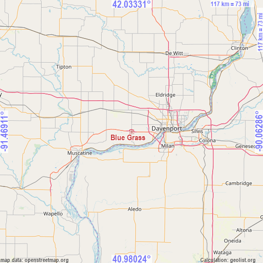
Blue Grass GPS coordinates[2]
41° 30' 32.112" North, 90° 45' 57.528" West
| Map corner | latitude | longitude |
|---|---|---|
| Upper-left | 42.03331°, | -91.46911° |
| Center: | 41.50892°, | -90.76598° |
| Lower-right: | 40.98024°, | -90.06286° |
| Map W x H: | 117.1×117.1 km | = 72.8×72.8mi |
| max Lat: | 71.29058° ⇑29.1% North |
| Blue Grass: | 41.50892° |
| min Lat: | ⇓70.9% South 19.06759° |
| min Long | Blue Grass | max Long |
| -171.73463° | -90.76598° | -66.98998° |
| W 38.4%⇐ | ⇒61.6% E |
Elevation
Elevation of Blue Grass is 242 m = 794 ft, and this is 52.8 m = 173 ft below average elevation for this country.
| Max E: |
3189 m = 10463 ft | 39.5% |
| Avg. | 294.8 m = 967 ft | |
| Blue Grass | 242 m = 794 ft | |
Min E: |
-60 m = -197 ft | 60.5% |
See also: United States elevation on elevation.city.
Geographical zone
Blue Grass is located in North temperate zone (between Tropic of Cancer and the Arctic Circle). Distance of this Northern Tropic circle is 2009.4 km =1248.6 mi to South.| Distance of | km | miles | from Blue Grass |
|---|---|---|---|
| North Pole | 5391.7 | 3350.2 | to North |
| Arctic Circle | 2785.8 | 1731 | to North |
| Tropic Cancer | 2009.4 | 1248.6 | to South |
| Equator | 4615.4 | 2867.9 | to South |


Nearby cities:
15 places around Blue Grass: (largest is in red/bold)
• Andalusia
8.7 km =5.4 mi,  152°
152°
• Bettendorf
20.9 km =13 mi,  85°
85°
• Buffalo
6.8 km =4.2 mi, 148°
• Coyne Center
20.8 km =12.9 mi,  123°
123°
• Davenport
15.8 km =9.8 mi,  84°
84°
• Durant
15.7 km =9.8 mi,  309°
309°
• Eldridge
22.4 km =13.9 mi,  42°
42°
• Milan
17.3 km =10.7 mi,  111°
111°
• Moline
20.9 km =13 mi, 90°
• Muscatine
24.9 km =15.5 mi,  247°
247°
• Oak Grove
19.6 km =12.2 mi, 123°
• Reynolds
21.5 km =13.4 mi,  158°
158°
• Rock Island
15.6 km =9.7 mi, 89°
• Walcott
8.4 km =5.2 mi,  356°
356°
• Wilton
22.7 km =14.1 mi,  293°
293°
Sources, notices
• [Note1] Compared only with cities in United States existing in our database
• [Src1] Map data: © OpenStreetMap contributors (CC-BY-SA)
• [Src2] Other city data from geonames.org with taken over terms of usage.
• [Src3] Geographical zone / Annual Mean Temperature by Robert A. Rohde @ Wikipedia
