Odebolt geodata
Odebolt (Iowa) is a populated place; located in United States in America/Chicago (GMT-5) time zone. With population of 978 people, there are 16430 cities with bigger population in this country. Compared to other cities in United States, 78.2% of cities are located further ↓South; 71.7% of cities are located further →East and 84.7% of cities have lower elevation than Odebolt. Note1


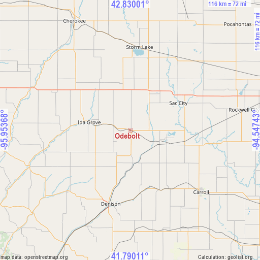
Odebolt GPS coordinates[2]
42° 18' 43.956" North, 95° 15' 1.98" West
| Map corner | latitude | longitude |
|---|---|---|
| Upper-left | 42.83001°, | -95.95368° |
| Center: | 42.31221°, | -95.25055° |
| Lower-right: | 41.79011°, | -94.54743° |
| Map W x H: | 115.6×115.6 km | = 71.8×71.8mi |
| max Lat: | 71.29058° ⇑21.8% North |
| Odebolt: | 42.31221° |
| min Lat: | ⇓78.2% South 19.06759° |
| min Long | Odebolt | max Long |
| -171.73463° | -95.25055° | -66.98998° |
| W 28.3%⇐ | ⇒71.7% E |
Elevation
Elevation of Odebolt is 417 m = 1368 ft, and this is 122.2 m = 401 ft above average elevation for this country.
| Max E: |
3189 m = 10463 ft | 15.3% |
| Odebolt | 417 m 1368 ft | |
| Avg. | 294.8 m = 967 ft | |
Min E: |
-60 m = -197 ft | 84.7% |
See also: United States elevation on elevation.city.
Geographical zone
Odebolt is located in North temperate zone (between Tropic of Cancer and the Arctic Circle). Distance of this Northern Tropic circle is 2098.8 km =1304.1 mi to South.| Distance of | km | miles | from Odebolt |
|---|---|---|---|
| North Pole | 5302.4 | 3294.8 | to North |
| Arctic Circle | 2696.5 | 1675.5 | to North |
| Tropic Cancer | 2098.8 | 1304.1 | to South |
| Equator | 4704.7 | 2923.4 | to South |


Nearby cities:
15 places around Odebolt: (largest is in red/bold)
• Alta
40.3 km =25 mi,  355°
355°
• Battle Creek
28.6 km =17.8 mi,  270°
270°
• Carroll
41.8 km =26 mi,  130°
130°
• Denison
33.9 km =21.1 mi,  194°
194°
• Early
18.5 km =11.5 mi,  26°
26°
• Holstein
31.2 km =19.4 mi,  309°
309°
• Ida Grove
18.5 km =11.5 mi,  281°
281°
• Lake View
16.2 km =10.1 mi,  90°
90°
• Lakeside
35 km =21.7 mi,  10°
10°
• Newell
38.4 km =23.9 mi, 31°
• Sac City
24.7 km =15.3 mi,  60°
60°
• Schaller
21.1 km =13.1 mi,  350°
350°
• Schleswig
22.4 km =13.9 mi,  223°
223°
• Storm Lake
36.7 km =22.8 mi, 5°
• Wall Lake
13.7 km =8.5 mi,  109°
109°
Sources, notices
• [Note1] Compared only with cities in United States existing in our database
• [Src1] Map data: © OpenStreetMap contributors (CC-BY-SA)
• [Src2] Other city data from geonames.org with taken over terms of usage.
• [Src3] Geographical zone / Annual Mean Temperature by Robert A. Rohde @ Wikipedia
