Wall Lake geodata
Wall Lake (Iowa) is a populated place; located in United States in America/Chicago (GMT-5) time zone. With population of 795 people, there are 17856 cities with bigger population in this country. Compared to other cities in United States, 78% of cities are located further ↓South; 71.3% of cities are located further →East and 82.4% of cities have lower elevation than Wall Lake. Note1


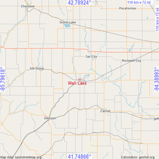
Wall Lake GPS coordinates[2]
42° 16' 15.96" North, 95° 5' 34.98" West
| Map corner | latitude | longitude |
|---|---|---|
| Upper-left | 42.78924°, | -95.79618° |
| Center: | 42.2711°, | -95.09305° |
| Lower-right: | 41.74866°, | -94.38993° |
| Map W x H: | 115.7×115.7 km | = 71.9×71.9mi |
| max Lat: | 71.29058° ⇑22% North |
| Wall Lake: | 42.2711° |
| min Lat: | ⇓78% South 19.06759° |
| min Long | Wall Lake | max Long |
| -171.73463° | -95.09305° | -66.98998° |
| W 28.7%⇐ | ⇒71.3% E |
Elevation
Elevation of Wall Lake is 381 m = 1250 ft, and this is 86.2 m = 283 ft above average elevation for this country.
| Max E: |
3189 m = 10463 ft | 17.6% |
| Wall Lake | 381 m 1250 ft | |
| Avg. | 294.8 m = 967 ft | |
Min E: |
-60 m = -197 ft | 82.4% |
See also: United States elevation on elevation.city.
Geographical zone
Wall Lake is located in North temperate zone (between Tropic of Cancer and the Arctic Circle). Distance of this Northern Tropic circle is 2094.2 km =1301.3 mi to South.| Distance of | km | miles | from Wall Lake |
|---|---|---|---|
| North Pole | 5307 | 3297.6 | to North |
| Arctic Circle | 2701.1 | 1678.4 | to North |
| Tropic Cancer | 2094.2 | 1301.3 | to South |
| Equator | 4700.1 | 2920.5 | to South |


Nearby cities:
15 places around Wall Lake: (largest is in red/bold)
• Carroll
29.5 km =18.3 mi,  140°
140°
• Denison
35.5 km =22.1 mi,  217°
217°
• Early
21.7 km =13.5 mi,  347°
347°
• Fonda
40 km =24.9 mi,  30°
30°
• Glidden
38.3 km =23.8 mi,  128°
128°
• Ida Grove
32.2 km =20 mi,  284°
284°
• Lake City
29.6 km =18.4 mi,  90°
90°
• Lake View
5.6 km =3.5 mi,  35°
35°
• Lakeside
39.5 km =24.5 mi, 350°
• Newell
37.9 km =23.5 mi,  11°
11°
• Odebolt
13.7 km =8.5 mi,  289°
289°
• Rockwell City
40.2 km =25 mi,  69°
69°
• Sac City
18.8 km =11.7 mi, 26°
• Schaller
30.3 km =18.8 mi,  327°
327°
• Schleswig
30.7 km =19.1 mi,  247°
247°
Sources, notices
• [Note1] Compared only with cities in United States existing in our database
• [Src1] Map data: © OpenStreetMap contributors (CC-BY-SA)
• [Src2] Other city data from geonames.org with taken over terms of usage.
• [Src3] Geographical zone / Annual Mean Temperature by Robert A. Rohde @ Wikipedia
