Carroll geodata
Carroll (Iowa) is a seat of a second-order administrative division; located in United States in America/Chicago (GMT-5) time zone. With population of 9,968 people, there are 4475 cities with bigger population in this country. Compared to other cities in United States, 76.2% of cities are located further ↓South; 70.8% of cities are located further →East and 82.7% of cities have lower elevation than Carroll. Note1


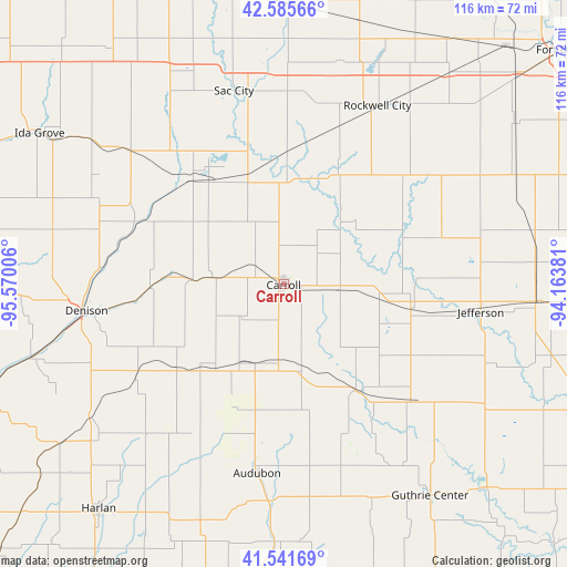
Carroll GPS coordinates[2]
42° 3' 56.952" North, 94° 52' 0.948" West
| Map corner | latitude | longitude |
|---|---|---|
| Upper-left | 42.58566°, | -95.57006° |
| Center: | 42.06582°, | -94.86693° |
| Lower-right: | 41.54169°, | -94.16381° |
| Map W x H: | 116.1×116.1 km | = 72.1×72.1mi |
| max Lat: | 71.29058° ⇑23.8% North |
| Carroll: | 42.06582° |
| min Lat: | ⇓76.2% South 19.06759° |
| min Long | Carroll | max Long |
| -171.73463° | -94.86693° | -66.98998° |
| W 29.2%⇐ | ⇒70.8% E |
Elevation
Elevation of Carroll is 385 m = 1263 ft, and this is 90.2 m = 296 ft above average elevation for this country.
| Max E: |
3189 m = 10463 ft | 17.3% |
| Carroll | 385 m 1263 ft | |
| Avg. | 294.8 m = 967 ft | |
Min E: |
-60 m = -197 ft | 82.7% |
See also: United States elevation on elevation.city.
Geographical zone
Carroll is located in North temperate zone (between Tropic of Cancer and the Arctic Circle). Distance of this Northern Tropic circle is 2071.4 km =1287.1 mi to South.| Distance of | km | miles | from Carroll |
|---|---|---|---|
| North Pole | 5329.8 | 3311.8 | to North |
| Arctic Circle | 2723.9 | 1692.6 | to North |
| Tropic Cancer | 2071.4 | 1287.1 | to South |
| Equator | 4677.3 | 2906.3 | to South |


Nearby cities:
15 places around Carroll: (largest is in red/bold)
• Audubon
39 km =24.2 mi,  187°
187°
• Coon Rapids
26.7 km =16.6 mi,  144°
144°
• Denison
40.7 km =25.3 mi,  262°
262°
• Glidden
11.4 km =7.1 mi,  94°
94°
• Jefferson
40.8 km =25.4 mi,  97°
97°
• Lake City
25 km =15.5 mi,  26°
26°
• Lake View
31.4 km =19.5 mi,  330°
330°
• Manilla
36 km =22.4 mi,  237°
237°
• Manning
23.9 km =14.9 mi,  223°
223°
• Odebolt
41.8 km =26 mi,  310°
310°
• Rockwell City
41.4 km =25.7 mi, 27°
• Sac City
40.9 km =25.4 mi,  345°
345°
• Schleswig
48.3 km =30 mi,  283°
283°
• Scranton
27 km =16.8 mi, 100°
• Wall Lake
29.5 km =18.3 mi,  320°
320°
Sources, notices
• [Note1] Compared only with cities in United States existing in our database
• [Src1] Map data: © OpenStreetMap contributors (CC-BY-SA)
• [Src2] Other city data from geonames.org with taken over terms of usage.
• [Src3] Geographical zone / Annual Mean Temperature by Robert A. Rohde @ Wikipedia
