Urbana geodata
Urbana (Iowa) is a populated place; located in United States in America/Chicago (GMT-5) time zone. With population of 1,459 people, there are 13843 cities with bigger population in this country. Compared to other cities in United States, 77.5% of cities are located further ↓South; 63.9% of cities are located further →East and 70.3% of cities have lower elevation than Urbana. Note1


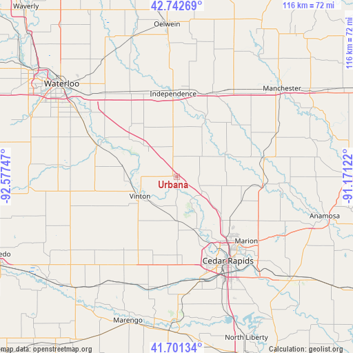
Urbana GPS coordinates[2]
42° 13' 26.976" North, 91° 52' 27.624" West
| Map corner | latitude | longitude |
|---|---|---|
| Upper-left | 42.74269°, | -92.57747° |
| Center: | 42.22416°, | -91.87434° |
| Lower-right: | 41.70134°, | -91.17122° |
| Map W x H: | 115.8×115.8 km | = 72×72mi |
| max Lat: | 71.29058° ⇑22.5% North |
| Urbana: | 42.22416° |
| min Lat: | ⇓77.5% South 19.06759° |
| min Long | Urbana | max Long |
| -171.73463° | -91.87434° | -66.98998° |
| W 36.1%⇐ | ⇒63.9% E |
Elevation
Elevation of Urbana is 287 m = 942 ft, and this is 7.8 m = 26 ft below average elevation for this country.
| Max E: |
3189 m = 10463 ft | 29.7% |
| Avg. | 294.8 m = 967 ft | |
| Urbana | 287 m = 942 ft | |
Min E: |
-60 m = -197 ft | 70.3% |
See also: United States elevation on elevation.city.
Geographical zone
Urbana is located in North temperate zone (between Tropic of Cancer and the Arctic Circle). Distance of this Northern Tropic circle is 2089 km =1298 mi to South.| Distance of | km | miles | from Urbana |
|---|---|---|---|
| North Pole | 5312.2 | 3300.8 | to North |
| Arctic Circle | 2706.3 | 1681.6 | to North |
| Tropic Cancer | 2089 | 1298 | to South |
| Equator | 4694.9 | 2917.3 | to South |


Nearby cities:
15 places around Urbana: (largest is in red/bold)
• Alburnett
22.7 km =14.1 mi,  111°
111°
• Atkins
25.3 km =15.7 mi,  177°
177°
• Center Point
8.2 km =5.1 mi,  116°
116°
• Central City
28.9 km =18 mi,  94°
94°
• Coggon
29 km =18 mi,  77°
77°
• Hiawatha
26.3 km =16.3 mi,  142°
142°
• Independence
27.2 km =16.9 mi,  357°
357°
• La Porte City
28 km =17.4 mi,  291°
291°
• Newhall
26.6 km =16.5 mi,  196°
196°
• Palo
18.7 km =11.6 mi,  159°
159°
• Quasqueton
21.1 km =13.1 mi,  26°
26°
• Robins
24.1 km =15 mi,  134°
134°
• Shellsburg
14.4 km =8.9 mi, 178°
• Vinton
13.8 km =8.6 mi,  243°
243°
• Walker
10.4 km =6.5 mi,  47°
47°
Sources, notices
• [Note1] Compared only with cities in United States existing in our database
• [Src1] Map data: © OpenStreetMap contributors (CC-BY-SA)
• [Src2] Other city data from geonames.org with taken over terms of usage.
• [Src3] Geographical zone / Annual Mean Temperature by Robert A. Rohde @ Wikipedia
