Urbandale geodata
Urbandale (Iowa) is a populated place; located in United States in America/Chicago (GMT-5) time zone. With population of 44,062 people, there are 1082 cities with bigger population in this country. Compared to other cities in United States, 72.1% of cities are located further ↓South; 68% of cities are located further →East and 70.3% of cities have lower elevation than Urbandale. Note1


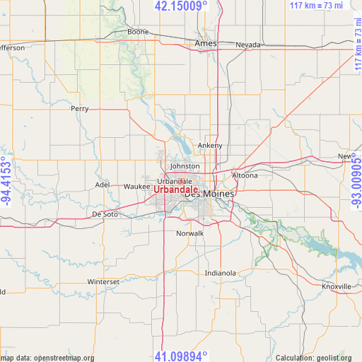
Urbandale GPS coordinates[2]
41° 37' 35.976" North, 93° 42' 43.812" West
| Map corner | latitude | longitude |
|---|---|---|
| Upper-left | 42.15009°, | -94.4153° |
| Center: | 41.62666°, | -93.71217° |
| Lower-right: | 41.09894°, | -93.00905° |
| Map W x H: | 116.9×116.9 km | = 72.6×72.6mi |
| max Lat: | 71.29058° ⇑27.9% North |
| Urbandale: | 41.62666° |
| min Lat: | ⇓72.1% South 19.06759° |
| min Long | Urbandale | max Long |
| -171.73463° | -93.71217° | -66.98998° |
| W 32%⇐ | ⇒68% E |
Elevation
Elevation of Urbandale is 287 m = 942 ft, and this is 7.8 m = 26 ft below average elevation for this country.
| Max E: |
3189 m = 10463 ft | 29.7% |
| Avg. | 294.8 m = 967 ft | |
| Urbandale | 287 m = 942 ft | |
Min E: |
-60 m = -197 ft | 70.3% |
See also: Urbandale elevation on elevation.city.
Geographical zone
Urbandale is located in North temperate zone (between Tropic of Cancer and the Arctic Circle). Distance of this Northern Tropic circle is 2022.5 km =1256.7 mi to South.| Distance of | km | miles | from Urbandale |
|---|---|---|---|
| North Pole | 5378.6 | 3342.1 | to North |
| Arctic Circle | 2772.7 | 1722.9 | to North |
| Tropic Cancer | 2022.5 | 1256.7 | to South |
| Equator | 4628.5 | 2876 | to South |


Nearby cities:
15 places around Urbandale: (largest is in red/bold)
• Altoona
20.7 km =12.9 mi,  84°
84°
• Ankeny
14.5 km =9 mi,  37°
37°
• Clive
2.8 km =1.7 mi,  200°
200°
• Dallas Center
21.7 km =13.5 mi,  287°
287°
• Des Moines
9 km =5.6 mi,  108°
108°
• Granger
17.6 km =10.9 mi,  328°
328°
• Grimes
9.5 km =5.9 mi,  316°
316°
• Johnston
5.3 km =3.3 mi,  13°
13°
• Norwalk
17 km =10.6 mi,  170°
170°
• Pleasant Hill
16.7 km =10.4 mi, 106°
• Polk City
16.1 km =10 mi,  359°
359°
• Saylorville
9 km =5.6 mi,  49°
49°
• Waukee
14.5 km =9 mi,  263°
263°
• West Des Moines
5.5 km =3.4 mi,  179°
179°
• Windsor Heights
3.2 km =2 mi, 174°
Sources, notices
• [Note1] Compared only with cities in United States existing in our database
• [Src1] Map data: © OpenStreetMap contributors (CC-BY-SA)
• [Src2] Other city data from geonames.org with taken over terms of usage.
• [Src3] Geographical zone / Annual Mean Temperature by Robert A. Rohde @ Wikipedia
