Pleasant Hill geodata
Pleasant Hill (Iowa) is a populated place; located in United States in America/Chicago (GMT-5) time zone. With population of 9,314 people, there are 4684 cities with bigger population in this country. Compared to other cities in United States, 71.7% of cities are located further ↓South; 67.5% of cities are located further →East and 63.5% of cities have lower elevation than Pleasant Hill. Note1


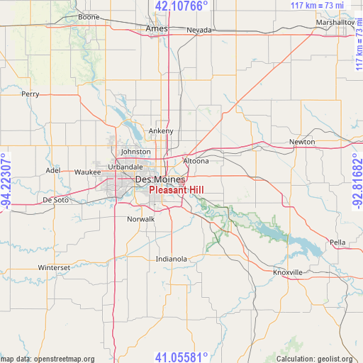
Pleasant Hill GPS coordinates[2]
41° 35' 1.968" North, 93° 31' 11.784" West
| Map corner | latitude | longitude |
|---|---|---|
| Upper-left | 42.10766°, | -94.22307° |
| Center: | 41.58388°, | -93.51994° |
| Lower-right: | 41.05581°, | -92.81682° |
| Map W x H: | 117×117 km | = 72.7×72.7mi |
| max Lat: | 71.29058° ⇑28.3% North |
| Pleasant Hill: | 41.58388° |
| min Lat: | ⇓71.7% South 19.06759° |
| min Long | Pleasant Hill | max Long |
| -171.73463° | -93.51994° | -66.98998° |
| W 32.5%⇐ | ⇒67.5% E |
Elevation
Elevation of Pleasant Hill is 255 m = 837 ft, and this is 39.8 m = 131 ft below average elevation for this country.
| Max E: |
3189 m = 10463 ft | 36.5% |
| Avg. | 294.8 m = 967 ft | |
| Pleasant Hill | 255 m = 837 ft | |
Min E: |
-60 m = -197 ft | 63.5% |
See also: United States elevation on elevation.city.
Geographical zone
Pleasant Hill is located in North temperate zone (between Tropic of Cancer and the Arctic Circle). Distance of this Northern Tropic circle is 2017.8 km =1253.8 mi to South.| Distance of | km | miles | from Pleasant Hill |
|---|---|---|---|
| North Pole | 5383.4 | 3345.1 | to North |
| Arctic Circle | 2777.5 | 1725.9 | to North |
| Tropic Cancer | 2017.8 | 1253.8 | to South |
| Equator | 4623.7 | 2873 | to South |


Nearby cities:
15 places around Pleasant Hill: (largest is in red/bold)
• Altoona
8.1 km =5 mi,  34°
34°
• Ankeny
17.7 km =11 mi,  336°
336°
• Bondurant
13.8 km =8.6 mi,  20°
20°
• Carlisle
9.5 km =5.9 mi,  165°
165°
• Clive
17.1 km =10.6 mi,  277°
277°
• Des Moines
7.6 km =4.7 mi, 284°
• Hartford
16.8 km =10.4 mi,  145°
145°
• Johnston
17.8 km =11.1 mi,  303°
303°
• Mitchellville
16.4 km =10.2 mi,  55°
55°
• Norwalk
17.9 km =11.1 mi,  227°
227°
• Runnells
15.8 km =9.8 mi,  120°
120°
• Saylorville
13.9 km =8.6 mi,  319°
319°
• Urbandale
16.7 km =10.4 mi,  286°
286°
• West Des Moines
15.9 km =9.9 mi,  267°
267°
• Windsor Heights
15.7 km =9.8 mi, 275°
Sources, notices
• [Note1] Compared only with cities in United States existing in our database
• [Src1] Map data: © OpenStreetMap contributors (CC-BY-SA)
• [Src2] Other city data from geonames.org with taken over terms of usage.
• [Src3] Geographical zone / Annual Mean Temperature by Robert A. Rohde @ Wikipedia
