Ankeny geodata
Ankeny (Iowa) is a populated place; located in United States in America/Chicago (GMT-5) time zone. With population of 56,764 people, there are 806 cities with bigger population in this country. Compared to other cities in United States, 73.2% of cities are located further ↓South; 67.8% of cities are located further →East and 72.8% of cities have lower elevation than Ankeny. Note1


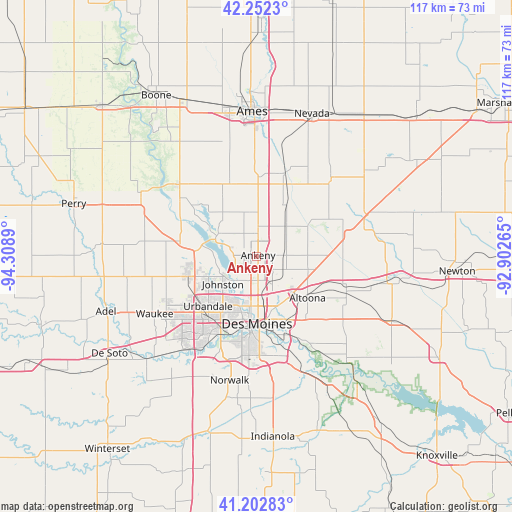
Ankeny GPS coordinates[2]
41° 43' 46.956" North, 93° 36' 20.772" West
| Map corner | latitude | longitude |
|---|---|---|
| Upper-left | 42.2523°, | -94.3089° |
| Center: | 41.72971°, | -93.60577° |
| Lower-right: | 41.20283°, | -92.90265° |
| Map W x H: | 116.7×116.7 km | = 72.5×72.5mi |
| max Lat: | 71.29058° ⇑26.8% North |
| Ankeny: | 41.72971° |
| min Lat: | ⇓73.2% South 19.06759° |
| min Long | Ankeny | max Long |
| -171.73463° | -93.60577° | -66.98998° |
| W 32.2%⇐ | ⇒67.8% E |
Elevation
Elevation of Ankeny is 300 m = 984 ft, and this is 5.2 m = 17 ft above average elevation for this country.
| Max E: |
3189 m = 10463 ft | 27.2% |
| Ankeny | 300 m 984 ft | |
| Avg. | 294.8 m = 967 ft | |
Min E: |
-60 m = -197 ft | 72.8% |
See also: Ankeny elevation on elevation.city.
Geographical zone
Ankeny is located in North temperate zone (between Tropic of Cancer and the Arctic Circle). Distance of this Northern Tropic circle is 2034 km =1263.9 mi to South.| Distance of | km | miles | from Ankeny |
|---|---|---|---|
| North Pole | 5367.2 | 3335 | to North |
| Arctic Circle | 2761.3 | 1715.8 | to North |
| Tropic Cancer | 2034 | 1263.9 | to South |
| Equator | 4639.9 | 2883.1 | to South |


Nearby cities:
15 places around Ankeny: (largest is in red/bold)
• Altoona
15.1 km =9.4 mi,  129°
129°
• Bondurant
12.4 km =7.7 mi,  105°
105°
• Clive
17.2 km =10.7 mi,  214°
214°
• Des Moines
14.4 km =8.9 mi,  181°
181°
• Elkhart
9.8 km =6.1 mi,  45°
45°
• Granger
18.5 km =11.5 mi,  280°
280°
• Grimes
16.1 km =10 mi,  253°
253°
• Huxley
18.4 km =11.4 mi,  1°
1°
• Johnston
9.9 km =6.2 mi,  230°
230°
• Pleasant Hill
17.7 km =11 mi,  156°
156°
• Polk City
10 km =6.2 mi,  297°
297°
• Saylorville
6 km =3.7 mi,  199°
199°
• Slater
17.5 km =10.9 mi,  339°
339°
• Urbandale
14.5 km =9 mi,  217°
217°
• Windsor Heights
17 km =10.6 mi, 210°
Sources, notices
• [Note1] Compared only with cities in United States existing in our database
• [Src1] Map data: © OpenStreetMap contributors (CC-BY-SA)
• [Src2] Other city data from geonames.org with taken over terms of usage.
• [Src3] Geographical zone / Annual Mean Temperature by Robert A. Rohde @ Wikipedia
