Mapleton geodata
Mapleton (Iowa) is a populated place; located in United States in America/Chicago (GMT-5) time zone. With population of 1,214 people, there are 15046 cities with bigger population in this country. Compared to other cities in United States, 77.1% of cities are located further ↓South; 73% of cities are located further →East and 79.2% of cities have lower elevation than Mapleton. Note1


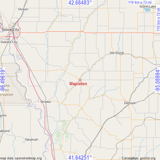
Mapleton GPS coordinates[2]
42° 9' 56.952" North, 95° 47' 35.016" West
| Map corner | latitude | longitude |
|---|---|---|
| Upper-left | 42.68483°, | -96.49619° |
| Center: | 42.16582°, | -95.79306° |
| Lower-right: | 41.64251°, | -95.08994° |
| Map W x H: | 115.9×115.9 km | = 72×72mi |
| max Lat: | 71.29058° ⇑22.9% North |
| Mapleton: | 42.16582° |
| min Lat: | ⇓77.1% South 19.06759° |
| min Long | Mapleton | max Long |
| -171.73463° | -95.79306° | -66.98998° |
| W 27%⇐ | ⇒73% E |
Elevation
Elevation of Mapleton is 346 m = 1135 ft, and this is 51.2 m = 168 ft above average elevation for this country.
| Max E: |
3189 m = 10463 ft | 20.8% |
| Mapleton | 346 m 1135 ft | |
| Avg. | 294.8 m = 967 ft | |
Min E: |
-60 m = -197 ft | 79.2% |
See also: United States elevation on elevation.city.
Geographical zone
Mapleton is located in North temperate zone (between Tropic of Cancer and the Arctic Circle). Distance of this Northern Tropic circle is 2082.5 km =1294 mi to South.| Distance of | km | miles | from Mapleton |
|---|---|---|---|
| North Pole | 5318.7 | 3304.9 | to North |
| Arctic Circle | 2712.8 | 1685.7 | to North |
| Tropic Cancer | 2082.5 | 1294 | to South |
| Equator | 4688.4 | 2913.2 | to South |


Nearby cities:
15 places around Mapleton: (largest is in red/bold)
• Anthon
25.5 km =15.8 mi,  346°
346°
• Battle Creek
23.1 km =14.4 mi,  43°
43°
• Correctionville
34.4 km =21.4 mi,  1°
1°
• Denison
39.7 km =24.7 mi,  114°
114°
• Dunlap
38.1 km =23.7 mi,  155°
155°
• Holstein
41.3 km =25.7 mi,  29°
29°
• Ida Grove
33.1 km =20.6 mi,  53°
53°
• Lawton
47.3 km =29.4 mi,  317°
317°
• Macy
46.8 km =29.1 mi,  262°
262°
• Moville
42.6 km =26.5 mi,  327°
327°
• Odebolt
47.5 km =29.5 mi,  69°
69°
• Onawa
29.5 km =18.3 mi,  238°
238°
• Schleswig
29.3 km =18.2 mi,  90°
90°
• Sloan
36.6 km =22.7 mi,  281°
281°
• Whiting
29.7 km =18.5 mi, 261°
Sources, notices
• [Note1] Compared only with cities in United States existing in our database
• [Src1] Map data: © OpenStreetMap contributors (CC-BY-SA)
• [Src2] Other city data from geonames.org with taken over terms of usage.
• [Src3] Geographical zone / Annual Mean Temperature by Robert A. Rohde @ Wikipedia
