Dunlap geodata
Dunlap (Illinois) is a populated place; located in United States in America/Chicago (GMT-5) time zone. With population of 1,417 people, there are 14030 cities with bigger population in this country. Compared to other cities in United States, 64.1% of cities are located further ↓South; 58.1% of cities are located further →East and 56.7% of cities have lower elevation than Dunlap. Note1


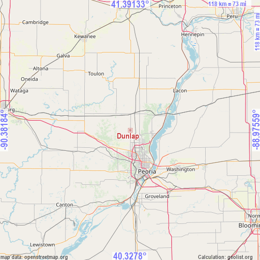
Dunlap GPS coordinates[2]
40° 51' 42.12" North, 89° 40' 43.356" West
| Map corner | latitude | longitude |
|---|---|---|
| Upper-left | 41.39133°, | -90.38184° |
| Center: | 40.8617°, | -89.67871° |
| Lower-right: | 40.3278°, | -88.97559° |
| Map W x H: | 118.3×118.3 km | = 73.5×73.5mi |
| max Lat: | 71.29058° ⇑35.9% North |
| Dunlap: | 40.8617° |
| min Lat: | ⇓64.1% South 19.06759° |
| min Long | Dunlap | max Long |
| -171.73463° | -89.67871° | -66.98998° |
| W 41.9%⇐ | ⇒58.1% E |
Elevation
Elevation of Dunlap is 225 m = 738 ft, and this is 69.8 m = 229 ft below average elevation for this country.
| Max E: |
3189 m = 10463 ft | 43.3% |
| Avg. | 294.8 m = 967 ft | |
| Dunlap | 225 m = 738 ft | |
Min E: |
-60 m = -197 ft | 56.7% |
See also: United States elevation on elevation.city.
Geographical zone
Dunlap is located in North temperate zone (between Tropic of Cancer and the Arctic Circle). Distance of this Northern Tropic circle is 1937.5 km =1203.9 mi to South.| Distance of | km | miles | from Dunlap |
|---|---|---|---|
| North Pole | 5463.7 | 3395 | to North |
| Arctic Circle | 2857.8 | 1775.8 | to North |
| Tropic Cancer | 1937.5 | 1203.9 | to South |
| Equator | 4543.4 | 2823.1 | to South |


Nearby cities:
15 places around Dunlap: (largest is in red/bold)
• Bartonville
23.6 km =14.7 mi,  174°
174°
• Bellevue
19.7 km =12.2 mi,  180°
180°
• Brimfield
17.7 km =11 mi,  261°
261°
• Chillicothe
17.5 km =10.9 mi,  67°
67°
• Creve Coeur
25 km =15.5 mi,  162°
162°
• East Peoria
23.3 km =14.5 mi, 159°
• Germantown Hills
20.7 km =12.9 mi,  120°
120°
• Hanna City
21.3 km =13.2 mi,  207°
207°
• North Peoria
17.9 km =11.1 mi,  153°
153°
• Peoria
20.2 km =12.6 mi, 157°
• Peoria Heights
15.5 km =9.6 mi, 145°
• Princeville
10.1 km =6.3 mi,  318°
318°
• Rome
15 km =9.3 mi,  80°
80°
• West Peoria
19.3 km =12 mi, 167°
• Wyoming
23.6 km =14.7 mi,  340°
340°
Sources, notices
• [Note1] Compared only with cities in United States existing in our database
• [Src1] Map data: © OpenStreetMap contributors (CC-BY-SA)
• [Src2] Other city data from geonames.org with taken over terms of usage.
• [Src3] Geographical zone / Annual Mean Temperature by Robert A. Rohde @ Wikipedia
