Hampshire geodata
Hampshire (Illinois) is a populated place; located in United States in America/Chicago (GMT-5) time zone. With population of 6,130 people, there are 6319 cities with bigger population in this country. Compared to other cities in United States, 76.5% of cities are located further ↓South; 54.8% of cities are located further →East and 68.2% of cities have lower elevation than Hampshire. Note1


Hampshire GPS coordinates[2]
42° 5' 52.08" North, 88° 31' 49.296" West
| Map corner | latitude | longitude |
|---|---|---|
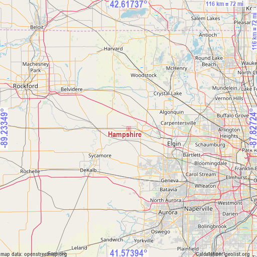
| Upper-left | 42.61737°, | -89.23349° |
| Center: | 42.0978°, | -88.53036° |
| Lower-right: | 41.57394°, | -87.82724° |
| Map W x H: | 116×116 km | = 72.1×72.1mi |
| max Lat: | 71.29058° ⇑23.5% North |
| Hampshire: | 42.0978° |
| min Lat: | ⇓76.5% South 19.06759° |
| min Long | Hampshire | max Long |
| -171.73463° | -88.53036° | -66.98998° |
| W 45.2%⇐ | ⇒54.8% E |
Elevation
Elevation of Hampshire is 277 m = 909 ft, and this is 17.8 m = 58 ft below average elevation for this country.
| Max E: |
3189 m = 10463 ft | 31.8% |
| Avg. | 294.8 m = 967 ft | |
| Hampshire | 277 m = 909 ft | |
Min E: |
-60 m = -197 ft | 68.2% |
See also: United States elevation on elevation.city.
Geographical zone
Hampshire is located in North temperate zone (between Tropic of Cancer and the Arctic Circle). Distance of this Northern Tropic circle is 2074.9 km =1289.3 mi to South.| Distance of | km | miles | from Hampshire |
|---|---|---|---|
| North Pole | 5326.2 | 3309.5 | to North |
| Arctic Circle | 2720.3 | 1690.3 | to North |
| Tropic Cancer | 2074.9 | 1289.3 | to South |
| Equator | 4680.8 | 2908.5 | to South |


Nearby cities:
15 places around Hampshire: (largest is in red/bold)
• Burlington
5.2 km =3.2 mi,  196°
196°
• Genoa
13.4 km =8.3 mi,  269°
269°
• Gilberts
13 km =8.1 mi,  87°
87°
• Huntley
11.5 km =7.1 mi,  47°
47°
• Kingston
18.9 km =11.7 mi, 270°
• Lake in the Hills
18.9 km =11.7 mi,  60°
60°
• Lakewood
20.5 km =12.7 mi,  44°
44°
• Lily Lake
17.1 km =10.6 mi,  165°
165°
• Marengo
18 km =11.2 mi,  339°
339°
• Pingree Grove
10.2 km =6.3 mi,  108°
108°
• Sleepy Hollow
18.8 km =11.7 mi, 91°
• Sycamore
17.7 km =11 mi,  226°
226°
• Union
15.1 km =9.4 mi,  356°
356°
• Wasco
20.6 km =12.8 mi,  149°
149°
• West Dundee
20.4 km =12.7 mi, 89°
Sources, notices
• [Note1] Compared only with cities in United States existing in our database
• [Src1] Map data: © OpenStreetMap contributors (CC-BY-SA)
• [Src2] Other city data from geonames.org with taken over terms of usage.
• [Src3] Geographical zone / Annual Mean Temperature by Robert A. Rohde @ Wikipedia
