Genoa geodata
Genoa (Illinois) is a populated place; located in United States in America/Chicago (GMT-5) time zone. With population of 5,196 people, there are 7007 cities with bigger population in this country. Compared to other cities in United States, 76.5% of cities are located further ↓South; 55.4% of cities are located further →East and 63.7% of cities have lower elevation than Genoa. Note1


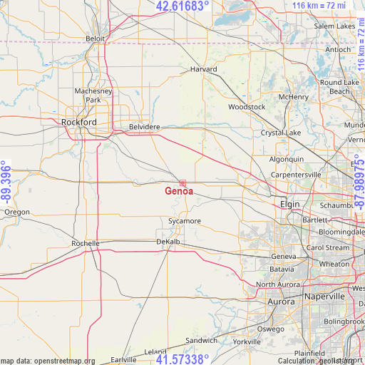
Genoa GPS coordinates[2]
42° 5' 50.1" North, 88° 41' 34.332" West
| Map corner | latitude | longitude |
|---|---|---|
| Upper-left | 42.61683°, | -89.396° |
| Center: | 42.09725°, | -88.69287° |
| Lower-right: | 41.57338°, | -87.98975° |
| Map W x H: | 116×116 km | = 72.1×72.1mi |
| max Lat: | 71.29058° ⇑23.5% North |
| Genoa: | 42.09725° |
| min Lat: | ⇓76.5% South 19.06759° |
| min Long | Genoa | max Long |
| -171.73463° | -88.69287° | -66.98998° |
| W 44.6%⇐ | ⇒55.4% E |
Elevation
Elevation of Genoa is 256 m = 840 ft, and this is 38.8 m = 127 ft below average elevation for this country.
| Max E: |
3189 m = 10463 ft | 36.3% |
| Avg. | 294.8 m = 967 ft | |
| Genoa | 256 m = 840 ft | |
Min E: |
-60 m = -197 ft | 63.7% |
See also: United States elevation on elevation.city.
Geographical zone
Genoa is located in North temperate zone (between Tropic of Cancer and the Arctic Circle). Distance of this Northern Tropic circle is 2074.9 km =1289.3 mi to South.| Distance of | km | miles | from Genoa |
|---|---|---|---|
| North Pole | 5326.3 | 3309.6 | to North |
| Arctic Circle | 2720.4 | 1690.4 | to North |
| Tropic Cancer | 2074.9 | 1289.3 | to South |
| Equator | 4680.8 | 2908.5 | to South |


Nearby cities:
15 places around Genoa: (largest is in red/bold)
• Belvidere
22.3 km =13.9 mi,  326°
326°
• Burlington
12.9 km =8 mi,  112°
112°
• Cortland
19.7 km =12.2 mi,  178°
178°
• DeKalb
19.3 km =12 mi,  194°
194°
• Hampshire
13.4 km =8.3 mi,  89°
89°
• Huntley
23.2 km =14.4 mi,  70°
70°
• Kingston
5.5 km =3.4 mi,  272°
272°
• Kirkland
13.1 km =8.1 mi, 267°
• Lily Lake
24.2 km =15 mi,  132°
132°
• Malta
23.2 km =14.4 mi,  216°
216°
• Maple Park
22.5 km =14 mi,  159°
159°
• Marengo
18.2 km =11.3 mi,  22°
22°
• Pingree Grove
23.3 km =14.5 mi,  97°
97°
• Sycamore
12.1 km =7.5 mi, 177°
• Union
19.5 km =12.1 mi,  39°
39°
Sources, notices
• [Note1] Compared only with cities in United States existing in our database
• [Src1] Map data: © OpenStreetMap contributors (CC-BY-SA)
• [Src2] Other city data from geonames.org with taken over terms of usage.
• [Src3] Geographical zone / Annual Mean Temperature by Robert A. Rohde @ Wikipedia
