Macomb geodata
Macomb (Illinois) is a seat of a second-order administrative division; located in United States in America/Chicago (GMT-5) time zone. With population of 18,547 people, there are 2708 cities with bigger population in this country. Compared to other cities in United States, 58.5% of cities are located further ↓South; 61.4% of cities are located further →East and 54.4% of cities have lower elevation than Macomb. Note1
Administrative division(s):
- Level 1: Illinois
- Level 2: McDonough County
- Level 3: Township of Macomb City


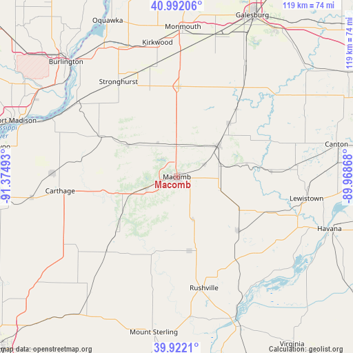
Macomb GPS coordinates[2]
40° 27' 33.156" North, 90° 40' 18.48" West
| Map corner | latitude | longitude |
|---|---|---|
| Upper-left | 40.99206°, | -91.37493° |
| Center: | 40.45921°, | -90.6718° |
| Lower-right: | 39.9221°, | -89.96868° |
| Map W x H: | 119×119 km | = 73.9×73.9mi |
| max Lat: | 71.29058° ⇑41.5% North |
| Macomb: | 40.45921° |
| min Lat: | ⇓58.5% South 19.06759° |
| min Long | Macomb | max Long |
| -171.73463° | -90.6718° | -66.98998° |
| W 38.6%⇐ | ⇒61.4% E |
Elevation
Elevation of Macomb is 216 m = 709 ft, and this is 78.8 m = 259 ft below average elevation for this country.
| Max E: |
3189 m = 10463 ft | 45.6% |
| Avg. | 294.8 m = 967 ft | |
| Macomb | 216 m = 709 ft | |
Min E: |
-60 m = -197 ft | 54.4% |
See also: United States elevation on elevation.city.
Geographical zone
Macomb is located in North temperate zone (between Tropic of Cancer and the Arctic Circle). Distance of this Northern Tropic circle is 1892.7 km =1176.1 mi to South.| Distance of | km | miles | from Macomb |
|---|---|---|---|
| North Pole | 5508.4 | 3422.8 | to North |
| Arctic Circle | 2902.5 | 1803.5 | to North |
| Tropic Cancer | 1892.7 | 1176.1 | to South |
| Equator | 4498.6 | 2795.3 | to South |


Nearby cities:
15 places around Macomb: (largest is in red/bold)
• Abingdon
44.6 km =27.7 mi,  30°
30°
• Astoria
36.9 km =22.9 mi,  134°
134°
• Augusta
34.7 km =21.6 mi,  222°
222°
• Avon
30.3 km =18.8 mi,  41°
41°
• Blandinsville
19.6 km =12.2 mi,  303°
303°
• Bushnell
17.4 km =10.8 mi,  53°
53°
• Carthage
39.6 km =24.6 mi,  263°
263°
• Colchester
10.9 km =6.8 mi,  250°
250°
• Cuba
40.9 km =25.4 mi,  84°
84°
• La Harpe
28.7 km =17.8 mi, 298°
• Lewistown
44.4 km =27.6 mi,  99°
99°
• Roseville
30.4 km =18.9 mi,  1°
1°
• Rushville
38.7 km =24 mi,  166°
166°
• Stronghurst
37.5 km =23.3 mi,  328°
328°
• Vermont
27.6 km =17.1 mi, 131°
Sources, notices
• [Note1] Compared only with cities in United States existing in our database
• [Src1] Map data: © OpenStreetMap contributors (CC-BY-SA)
• [Src2] Other city data from geonames.org with taken over terms of usage.
• [Src3] Geographical zone / Annual Mean Temperature by Robert A. Rohde @ Wikipedia
