Avon geodata
Avon (Illinois) is a populated place; located in United States in America/Chicago (GMT-5) time zone. With population of 757 people, there are 18155 cities with bigger population in this country. Compared to other cities in United States, 61% of cities are located further ↓South; 60.7% of cities are located further →East and 50% of cities have lower elevation than Avon. Note1


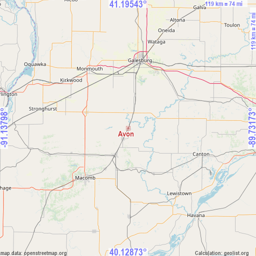
Avon GPS coordinates[2]
40° 39' 51.156" North, 90° 26' 5.46" West
| Map corner | latitude | longitude |
|---|---|---|
| Upper-left | 41.19543°, | -91.13798° |
| Center: | 40.66421°, | -90.43485° |
| Lower-right: | 40.12873°, | -89.73173° |
| Map W x H: | 118.6×118.6 km | = 73.7×73.7mi |
| max Lat: | 71.29058° ⇑39% North |
| Avon: | 40.66421° |
| min Lat: | ⇓61% South 19.06759° |
| min Long | Avon | max Long |
| -171.73463° | -90.43485° | -66.98998° |
| W 39.3%⇐ | ⇒60.7% E |
Elevation
Elevation of Avon is 198 m = 650 ft, and this is 96.8 m = 318 ft below average elevation for this country.
| Max E: |
3189 m = 10463 ft | 50% |
| Avg. | 294.8 m = 967 ft | |
| Avon | 198 m = 650 ft | |
Min E: |
-60 m = -197 ft | 50% |
See also: United States elevation on elevation.city.
Geographical zone
Avon is located in North temperate zone (between Tropic of Cancer and the Arctic Circle). Distance of this Northern Tropic circle is 1915.5 km =1190.2 mi to South.| Distance of | km | miles | from Avon |
|---|---|---|---|
| North Pole | 5485.6 | 3408.6 | to North |
| Arctic Circle | 2879.7 | 1789.4 | to North |
| Tropic Cancer | 1915.5 | 1190.2 | to South |
| Equator | 4521.4 | 2809.5 | to South |


Nearby cities:
15 places around Avon: (largest is in red/bold)
• Abingdon
15.8 km =9.8 mi,  10°
10°
• Bushnell
13.8 km =8.6 mi,  205°
205°
• Canton
35.7 km =22.2 mi,  109°
109°
• Cuba
28.1 km =17.5 mi,  132°
132°
• East Galesburg
33.2 km =20.6 mi,  18°
18°
• Farmington
36.4 km =22.6 mi,  84°
84°
• Galesburg
32 km =19.9 mi, 9°
• Kirkwood
34.6 km =21.5 mi,  310°
310°
• Knoxville
29.9 km =18.6 mi, 24°
• Lewistown
38.3 km =23.8 mi,  141°
141°
• Macomb
30.3 km =18.8 mi,  221°
221°
• Monmouth
32.8 km =20.4 mi,  326°
326°
• Roseville
20.8 km =12.9 mi,  291°
291°
• Saint David
37.7 km =23.4 mi,  120°
120°
• Yates City
37.6 km =23.4 mi,  70°
70°
Sources, notices
• [Note1] Compared only with cities in United States existing in our database
• [Src1] Map data: © OpenStreetMap contributors (CC-BY-SA)
• [Src2] Other city data from geonames.org with taken over terms of usage.
• [Src3] Geographical zone / Annual Mean Temperature by Robert A. Rohde @ Wikipedia
