Abingdon geodata
Abingdon (Illinois) is a populated place; located in United States in America/Chicago (GMT-5) time zone. With population of 3,182 people, there are 9333 cities with bigger population in this country. Compared to other cities in United States, 63.3% of cities are located further ↓South; 60.5% of cities are located further →East and 58.2% of cities have lower elevation than Abingdon. Note1


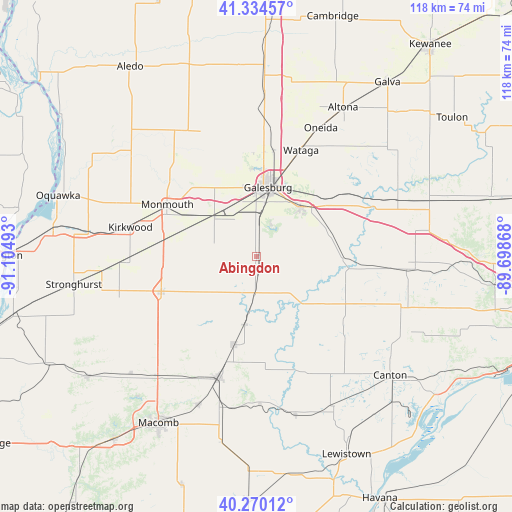
Abingdon GPS coordinates[2]
40° 48' 16.128" North, 90° 24' 6.48" West
| Map corner | latitude | longitude |
|---|---|---|
| Upper-left | 41.33457°, | -91.10493° |
| Center: | 40.80448°, | -90.4018° |
| Lower-right: | 40.27012°, | -89.69868° |
| Map W x H: | 118.4×118.4 km | = 73.6×73.6mi |
| max Lat: | 71.29058° ⇑36.7% North |
| Abingdon: | 40.80448° |
| min Lat: | ⇓63.3% South 19.06759° |
| min Long | Abingdon | max Long |
| -171.73463° | -90.4018° | -66.98998° |
| W 39.5%⇐ | ⇒60.5% E |
Elevation
Elevation of Abingdon is 231 m = 758 ft, and this is 63.8 m = 209 ft below average elevation for this country.
| Max E: |
3189 m = 10463 ft | 41.8% |
| Avg. | 294.8 m = 967 ft | |
| Abingdon | 231 m = 758 ft | |
Min E: |
-60 m = -197 ft | 58.2% |
See also: United States elevation on elevation.city.
Geographical zone
Abingdon is located in North temperate zone (between Tropic of Cancer and the Arctic Circle). Distance of this Northern Tropic circle is 1931.1 km =1199.9 mi to South.| Distance of | km | miles | from Abingdon |
|---|---|---|---|
| North Pole | 5470 | 3398.9 | to North |
| Arctic Circle | 2864.1 | 1779.7 | to North |
| Tropic Cancer | 1931.1 | 1199.9 | to South |
| Equator | 4537 | 2819.2 | to South |


Nearby cities:
15 places around Abingdon: (largest is in red/bold)
• Alexis
31.6 km =19.6 mi,  335°
335°
• Avon
15.8 km =9.8 mi,  190°
190°
• Bushnell
29.3 km =18.2 mi,  197°
197°
• East Galesburg
17.7 km =11 mi,  25°
25°
• Farmington
35.4 km =22 mi,  109°
109°
• Galesburg
16.1 km =10 mi,  9°
9°
• Kirkwood
30 km =18.6 mi,  283°
283°
• Knoxville
15.2 km =9.4 mi,  40°
40°
• Monmouth
23.8 km =14.8 mi,  299°
299°
• Oak Run
27.9 km =17.3 mi,  50°
50°
• Oneida
33.3 km =20.7 mi, 26°
• Roseville
23.5 km =14.6 mi,  250°
250°
• Wataga
26.6 km =16.5 mi,  22°
22°
• Williamsfield
35.1 km =21.8 mi,  68°
68°
• Yates City
32.7 km =20.3 mi,  95°
95°
Sources, notices
• [Note1] Compared only with cities in United States existing in our database
• [Src1] Map data: © OpenStreetMap contributors (CC-BY-SA)
• [Src2] Other city data from geonames.org with taken over terms of usage.
• [Src3] Geographical zone / Annual Mean Temperature by Robert A. Rohde @ Wikipedia
