North Chicago geodata
North Chicago (Illinois) is a populated place; located in United States in America/Chicago (GMT-5) time zone. With population of 29,491 people, there are 1691 cities with bigger population in this country. Compared to other cities in United States, 78.4% of cities are located further ↓South; 52.1% of cities are located further →East and 51.7% of cities have lower elevation than North Chicago. Note1


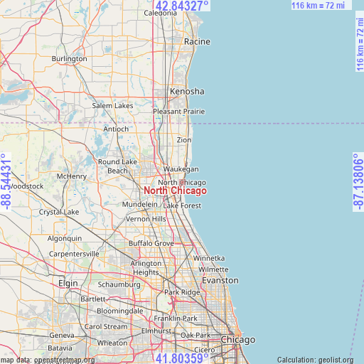
North Chicago GPS coordinates[2]
42° 19' 32.088" North, 87° 50' 28.248" West
| Map corner | latitude | longitude |
|---|---|---|
| Upper-left | 42.84327°, | -88.54431° |
| Center: | 42.32558°, | -87.84118° |
| Lower-right: | 41.80359°, | -87.13806° |
| Map W x H: | 115.6×115.6 km | = 71.8×71.8mi |
| max Lat: | 71.29058° ⇑21.6% North |
| North Chicago: | 42.32558° |
| min Lat: | ⇓78.4% South 19.06759° |
| min Long | North Chicago | max Long |
| -171.73463° | -87.84118° | -66.98998° |
| W 47.9%⇐ | ⇒52.1% E |
Elevation
Elevation of North Chicago is 205 m = 673 ft, and this is 89.8 m = 295 ft below average elevation for this country.
| Max E: |
3189 m = 10463 ft | 48.3% |
| Avg. | 294.8 m = 967 ft | |
| North Chicago | 205 m = 673 ft | |
Min E: |
-60 m = -197 ft | 51.7% |
See also: United States elevation on elevation.city.
Geographical zone
North Chicago is located in North temperate zone (between Tropic of Cancer and the Arctic Circle). Distance of this Northern Tropic circle is 2100.2 km =1305 mi to South.| Distance of | km | miles | from North Chicago |
|---|---|---|---|
| North Pole | 5300.9 | 3293.8 | to North |
| Arctic Circle | 2695 | 1674.6 | to North |
| Tropic Cancer | 2100.2 | 1305 | to South |
| Equator | 4706.2 | 2924.3 | to South |


Nearby cities:
15 places around North Chicago: (largest is in red/bold)
• Beach Park
10.8 km =6.7 mi,  352°
352°
• Gages Lake
12 km =7.5 mi,  284°
284°
• Grandwood Park
14.1 km =8.8 mi,  302°
302°
• Green Oaks
6.5 km =4 mi,  232°
232°
• Gurnee
7.1 km =4.4 mi,  314°
314°
• Highwood
14.2 km =8.8 mi,  169°
169°
• Knollwood
5.7 km =3.5 mi,  219°
219°
• Lake Bluff
5.2 km =3.2 mi, 173°
• Lake Forest
7.4 km =4.6 mi,  179°
179°
• Libertyville
10.3 km =6.4 mi,  242°
242°
• Mettawa
12.4 km =7.7 mi,  214°
214°
• Park City
4.4 km =2.7 mi, 305°
• Wadsworth
13.3 km =8.3 mi,  329°
329°
• Waukegan
4.2 km =2.6 mi,  355°
355°
• Zion
13.4 km =8.3 mi,  2°
2°
Sources, notices
• [Note1] Compared only with cities in United States existing in our database
• [Src1] Map data: © OpenStreetMap contributors (CC-BY-SA)
• [Src2] Other city data from geonames.org with taken over terms of usage.
• [Src3] Geographical zone / Annual Mean Temperature by Robert A. Rohde @ Wikipedia
