Waukegan geodata
Waukegan (Illinois) is a seat of a second-order administrative division; located in United States in America/Chicago (GMT-5) time zone. With population of 88,475 people, there are 418 cities with bigger population in this country. Compared to other cities in United States, 78.6% of cities are located further ↓South; 52.1% of cities are located further →East and 50.2% of cities have lower elevation than Waukegan. Note1


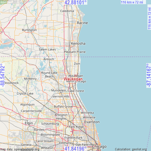
Waukegan GPS coordinates[2]
42° 21' 49.068" North, 87° 50' 41.244" West
| Map corner | latitude | longitude |
|---|---|---|
| Upper-left | 42.88101°, | -88.54792° |
| Center: | 42.36363°, | -87.84479° |
| Lower-right: | 41.84196°, | -87.14167° |
| Map W x H: | 115.5×115.5 km | = 71.8×71.8mi |
| max Lat: | 71.29058° ⇑21.4% North |
| Waukegan: | 42.36363° |
| min Lat: | ⇓78.6% South 19.06759° |
| min Long | Waukegan | max Long |
| -171.73463° | -87.84479° | -66.98998° |
| W 47.9%⇐ | ⇒52.1% E |
Elevation
Elevation of Waukegan is 199 m = 653 ft, and this is 95.8 m = 314 ft below average elevation for this country.
| Max E: |
3189 m = 10463 ft | 49.8% |
| Avg. | 294.8 m = 967 ft | |
| Waukegan | 199 m = 653 ft | |
Min E: |
-60 m = -197 ft | 50.2% |
See also: Waukegan elevation on elevation.city.
Geographical zone
Waukegan is located in North temperate zone (between Tropic of Cancer and the Arctic Circle). Distance of this Northern Tropic circle is 2104.5 km =1307.7 mi to South.| Distance of | km | miles | from Waukegan |
|---|---|---|---|
| North Pole | 5296.7 | 3291.2 | to North |
| Arctic Circle | 2690.8 | 1672 | to North |
| Tropic Cancer | 2104.5 | 1307.7 | to South |
| Equator | 4710.4 | 2926.9 | to South |


Nearby cities:
15 places around Waukegan: (largest is in red/bold)
• Beach Park
6.6 km =4.1 mi,  351°
351°
• Gages Lake
11.4 km =7.1 mi,  263°
263°
• Grandwood Park
12.1 km =7.5 mi,  285°
285°
• Green Oaks
9.5 km =5.9 mi,  210°
210°
• Gurnee
4.8 km =3 mi,  278°
278°
• Knollwood
9.2 km =5.7 mi,  201°
201°
• Lake Bluff
9.5 km =5.9 mi,  174°
174°
• Lake Forest
11.7 km =7.3 mi,  178°
178°
• Libertyville
12.6 km =7.8 mi,  224°
224°
• North Chicago
4.2 km =2.6 mi, 175°
• Park City
3.7 km =2.3 mi,  242°
242°
• Third Lake
13.7 km =8.5 mi,  274°
274°
• Wadsworth
9.7 km =6 mi,  318°
318°
• Winthrop Harbor
12.9 km =8 mi,  7°
7°
• Zion
9.2 km =5.7 mi, 6°
Sources, notices
• [Note1] Compared only with cities in United States existing in our database
• [Src1] Map data: © OpenStreetMap contributors (CC-BY-SA)
• [Src2] Other city data from geonames.org with taken over terms of usage.
• [Src3] Geographical zone / Annual Mean Temperature by Robert A. Rohde @ Wikipedia
