Palatine geodata
Palatine (Illinois) is a populated place; located in United States in America/Chicago (GMT-5) time zone. With population of 69,308 people, there are 601 cities with bigger population in this country. Compared to other cities in United States, 76.7% of cities are located further ↓South; 53% of cities are located further →East and 57.2% of cities have lower elevation than Palatine. Note1


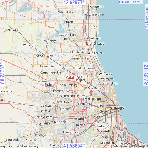
Palatine GPS coordinates[2]
42° 6' 37.08" North, 88° 2' 3.264" West
| Map corner | latitude | longitude |
|---|---|---|
| Upper-left | 42.62977°, | -88.73737° |
| Center: | 42.1103°, | -88.03424° |
| Lower-right: | 41.58654°, | -87.33112° |
| Map W x H: | 116×116 km | = 72.1×72.1mi |
| max Lat: | 71.29058° ⇑23.3% North |
| Palatine: | 42.1103° |
| min Lat: | ⇓76.7% South 19.06759° |
| min Long | Palatine | max Long |
| -171.73463° | -88.03424° | -66.98998° |
| W 47%⇐ | ⇒53% E |
Elevation
Elevation of Palatine is 227 m = 745 ft, and this is 67.8 m = 222 ft below average elevation for this country.
| Max E: |
3189 m = 10463 ft | 42.8% |
| Avg. | 294.8 m = 967 ft | |
| Palatine | 227 m = 745 ft | |
Min E: |
-60 m = -197 ft | 57.2% |
See also: Palatine elevation on elevation.city.
Geographical zone
Palatine is located in North temperate zone (between Tropic of Cancer and the Arctic Circle). Distance of this Northern Tropic circle is 2076.3 km =1290.2 mi to South.| Distance of | km | miles | from Palatine |
|---|---|---|---|
| North Pole | 5324.8 | 3308.7 | to North |
| Arctic Circle | 2718.9 | 1689.4 | to North |
| Tropic Cancer | 2076.3 | 1290.2 | to South |
| Equator | 4682.2 | 2909.4 | to South |


Nearby cities:
15 places around Palatine: (largest is in red/bold)
• Arlington Heights
5.1 km =3.2 mi,  118°
118°
• Barrington
9.7 km =6 mi,  299°
299°
• Barrington Hills
10.7 km =6.6 mi,  290°
290°
• Buffalo Grove
7.7 km =4.8 mi,  53°
53°
• Deer Park
6.8 km =4.2 mi,  325°
325°
• Hoffman Estates
8.4 km =5.2 mi,  206°
206°
• Inverness
5.2 km =3.2 mi,  279°
279°
• Kildeer
6.8 km =4.2 mi,  350°
350°
• Long Grove
8.1 km =5 mi,  21°
21°
• Mount Prospect
9.4 km =5.8 mi, 121°
• Prospect Heights
8.1 km =5 mi,  101°
101°
• Rolling Meadows
3.4 km =2.1 mi,  149°
149°
• Schaumburg
9.5 km =5.9 mi, 205°
• South Barrington
7.5 km =4.7 mi,  253°
253°
• Wheeling
9.3 km =5.8 mi,  69°
69°
Sources, notices
• [Note1] Compared only with cities in United States existing in our database
• [Src1] Map data: © OpenStreetMap contributors (CC-BY-SA)
• [Src2] Other city data from geonames.org with taken over terms of usage.
• [Src3] Geographical zone / Annual Mean Temperature by Robert A. Rohde @ Wikipedia
