Schaumburg geodata
Schaumburg (Illinois) is a populated place; located in United States in America/Chicago (GMT-5) time zone. With population of 74,693 people, there are 544 cities with bigger population in this country. Compared to other cities in United States, 76% of cities are located further ↓South; 53.3% of cities are located further →East and 61.4% of cities have lower elevation than Schaumburg. Note1


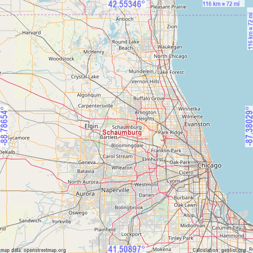
Schaumburg GPS coordinates[2]
42° 2' 0.096" North, 88° 5' 0.276" West
| Map corner | latitude | longitude |
|---|---|---|
| Upper-left | 42.55346°, | -88.78654° |
| Center: | 42.03336°, | -88.08341° |
| Lower-right: | 41.50897°, | -87.38029° |
| Map W x H: | 116.1×116.1 km | = 72.1×72.1mi |
| max Lat: | 71.29058° ⇑24% North |
| Schaumburg: | 42.03336° |
| min Lat: | ⇓76% South 19.06759° |
| min Long | Schaumburg | max Long |
| -171.73463° | -88.08341° | -66.98998° |
| W 46.7%⇐ | ⇒53.3% E |
Elevation
Elevation of Schaumburg is 246 m = 807 ft, and this is 48.8 m = 160 ft below average elevation for this country.
| Max E: |
3189 m = 10463 ft | 38.6% |
| Avg. | 294.8 m = 967 ft | |
| Schaumburg | 246 m = 807 ft | |
Min E: |
-60 m = -197 ft | 61.4% |
See also: Schaumburg elevation on elevation.city.
Geographical zone
Schaumburg is located in North temperate zone (between Tropic of Cancer and the Arctic Circle). Distance of this Northern Tropic circle is 2067.8 km =1284.9 mi to South.| Distance of | km | miles | from Schaumburg |
|---|---|---|---|
| North Pole | 5333.4 | 3314 | to North |
| Arctic Circle | 2727.5 | 1694.8 | to North |
| Tropic Cancer | 2067.8 | 1284.9 | to South |
| Equator | 4673.7 | 2904.1 | to South |


Nearby cities:
15 places around Schaumburg: (largest is in red/bold)
• Arlington Heights
10.5 km =6.5 mi,  54°
54°
• Bartlett
9.5 km =5.9 mi,  243°
243°
• Bloomingdale
8.4 km =5.2 mi,  178°
178°
• Elk Grove Village
9.9 km =6.2 mi,  109°
109°
• Hanover Park
6.3 km =3.9 mi,  233°
233°
• Hoffman Estates
1.1 km =0.7 mi,  15°
15°
• Inverness
9.5 km =5.9 mi,  353°
353°
• Itasca
9 km =5.6 mi,  135°
135°
• Mount Prospect
12.6 km =7.8 mi,  73°
73°
• Palatine
9.5 km =5.9 mi,  25°
25°
• Rolling Meadows
8.1 km =5 mi, 45°
• Roselle
5.4 km =3.4 mi, 176°
• South Barrington
7.2 km =4.5 mi,  333°
333°
• Streamwood
7.9 km =4.9 mi,  263°
263°
• Wood Dale
11.6 km =7.2 mi,  132°
132°
Sources, notices
• [Note1] Compared only with cities in United States existing in our database
• [Src1] Map data: © OpenStreetMap contributors (CC-BY-SA)
• [Src2] Other city data from geonames.org with taken over terms of usage.
• [Src3] Geographical zone / Annual Mean Temperature by Robert A. Rohde @ Wikipedia
