Rolling Meadows geodata
Rolling Meadows (Illinois) is a populated place; located in United States in America/Chicago (GMT-5) time zone. With population of 24,190 people, there are 2088 cities with bigger population in this country. Compared to other cities in United States, 76.4% of cities are located further ↓South; 52.9% of cities are located further →East and 55.6% of cities have lower elevation than Rolling Meadows. Note1


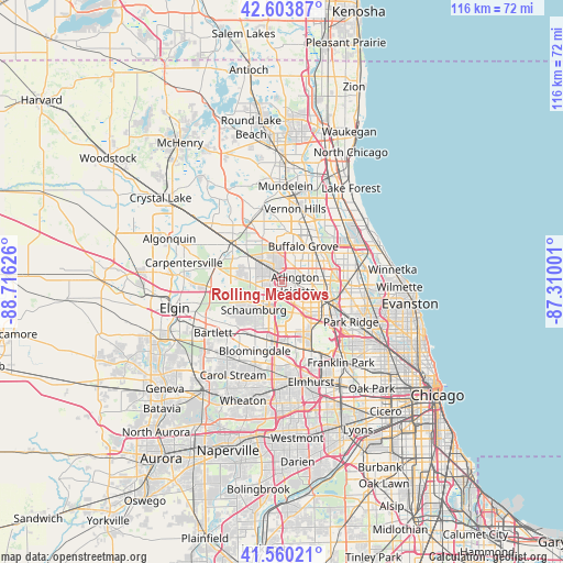
Rolling Meadows GPS coordinates[2]
42° 5' 3.084" North, 88° 0' 47.268" West
| Map corner | latitude | longitude |
|---|---|---|
| Upper-left | 42.60387°, | -88.71626° |
| Center: | 42.08419°, | -88.01313° |
| Lower-right: | 41.56021°, | -87.31001° |
| Map W x H: | 116×116 km | = 72.1×72.1mi |
| max Lat: | 71.29058° ⇑23.6% North |
| Rolling Meadows: | 42.08419° |
| min Lat: | ⇓76.4% South 19.06759° |
| min Long | Rolling Meadows | max Long |
| -171.73463° | -88.01313° | -66.98998° |
| W 47.1%⇐ | ⇒52.9% E |
Elevation
Elevation of Rolling Meadows is 221 m = 725 ft, and this is 73.8 m = 242 ft below average elevation for this country.
| Max E: |
3189 m = 10463 ft | 44.4% |
| Avg. | 294.8 m = 967 ft | |
| Rolling Meadows | 221 m = 725 ft | |
Min E: |
-60 m = -197 ft | 55.6% |
See also: United States elevation on elevation.city.
Geographical zone
Rolling Meadows is located in North temperate zone (between Tropic of Cancer and the Arctic Circle). Distance of this Northern Tropic circle is 2073.4 km =1288.4 mi to South.| Distance of | km | miles | from Rolling Meadows |
|---|---|---|---|
| North Pole | 5327.7 | 3310.5 | to North |
| Arctic Circle | 2721.9 | 1691.3 | to North |
| Tropic Cancer | 2073.4 | 1288.4 | to South |
| Equator | 4679.3 | 2907.6 | to South |


Nearby cities:
15 places around Rolling Meadows: (largest is in red/bold)
• Arlington Heights
2.7 km =1.7 mi,  80°
80°
• Buffalo Grove
8.7 km =5.4 mi,  30°
30°
• Deer Park
10.2 km =6.3 mi,  326°
326°
• Des Plaines
12.1 km =7.5 mi,  117°
117°
• Elk Grove Village
9.6 km =6 mi,  158°
158°
• Hoffman Estates
7.2 km =4.5 mi,  230°
230°
• Inverness
7.8 km =4.8 mi,  298°
298°
• Kildeer
10 km =6.2 mi,  343°
343°
• Long Grove
10.5 km =6.5 mi,  6°
6°
• Mount Prospect
6.6 km =4.1 mi,  107°
107°
• Palatine
3.4 km =2.1 mi, 329°
• Prospect Heights
6.4 km =4 mi, 78°
• Schaumburg
8.1 km =5 mi, 225°
• South Barrington
9 km =5.6 mi,  275°
275°
• Wheeling
9.3 km =5.8 mi,  48°
48°
Sources, notices
• [Note1] Compared only with cities in United States existing in our database
• [Src1] Map data: © OpenStreetMap contributors (CC-BY-SA)
• [Src2] Other city data from geonames.org with taken over terms of usage.
• [Src3] Geographical zone / Annual Mean Temperature by Robert A. Rohde @ Wikipedia
