Paxton geodata
Paxton (Illinois) is a seat of a second-order administrative division; located in United States in America/Chicago (GMT-5) time zone. With population of 4,357 people, there are 7800 cities with bigger population in this country. Compared to other cities in United States, 58.5% of cities are located further ↓South; 53.3% of cities are located further →East and 61.2% of cities have lower elevation than Paxton. Note1


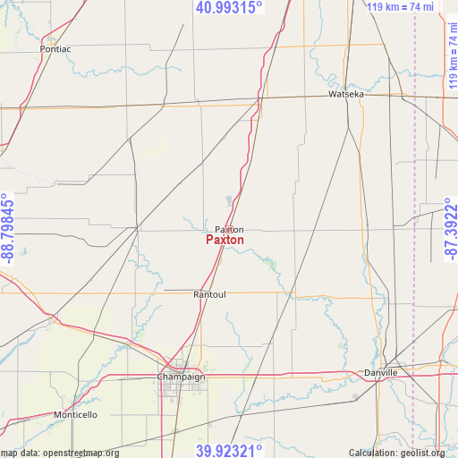
Paxton GPS coordinates[2]
40° 27' 37.116" North, 88° 5' 43.152" West
| Map corner | latitude | longitude |
|---|---|---|
| Upper-left | 40.99315°, | -88.79845° |
| Center: | 40.46031°, | -88.09532° |
| Lower-right: | 39.92321°, | -87.3922° |
| Map W x H: | 119×119 km | = 73.9×73.9mi |
| max Lat: | 71.29058° ⇑41.5% North |
| Paxton: | 40.46031° |
| min Lat: | ⇓58.5% South 19.06759° |
| min Long | Paxton | max Long |
| -171.73463° | -88.09532° | -66.98998° |
| W 46.7%⇐ | ⇒53.3% E |
Elevation
Elevation of Paxton is 245 m = 804 ft, and this is 49.8 m = 163 ft below average elevation for this country.
| Max E: |
3189 m = 10463 ft | 38.8% |
| Avg. | 294.8 m = 967 ft | |
| Paxton | 245 m = 804 ft | |
Min E: |
-60 m = -197 ft | 61.2% |
See also: United States elevation on elevation.city.
Geographical zone
Paxton is located in North temperate zone (between Tropic of Cancer and the Arctic Circle). Distance of this Northern Tropic circle is 1892.8 km =1176.1 mi to South.| Distance of | km | miles | from Paxton |
|---|---|---|---|
| North Pole | 5508.3 | 3422.7 | to North |
| Arctic Circle | 2902.4 | 1803.5 | to North |
| Tropic Cancer | 1892.8 | 1176.1 | to South |
| Equator | 4498.8 | 2795.4 | to South |


Nearby cities:
15 places around Paxton: (largest is in red/bold)
• Buckley
15.9 km =9.9 mi,  17°
17°
• Cissna Park
20.7 km =12.9 mi,  55°
55°
• Fisher
27 km =16.8 mi,  233°
233°
• Gibson City
24.5 km =15.2 mi,  269°
269°
• Gifford
18.3 km =11.4 mi,  159°
159°
• Gilman
35.2 km =21.9 mi,  14°
14°
• Hoopeston
36.1 km =22.4 mi,  88°
88°
• Lake of the Woods
36.5 km =22.7 mi,  219°
219°
• Onarga
29.3 km =18.2 mi, 14°
• Piper City
33.9 km =21.1 mi,  346°
346°
• Potomac
30.4 km =18.9 mi,  124°
124°
• Rankin
16.8 km =10.4 mi, 88°
• Rantoul
17.7 km =11 mi,  196°
196°
• Saybrook
36.6 km =22.7 mi,  264°
264°
• Thomasboro
25.4 km =15.8 mi, 197°
Sources, notices
• [Note1] Compared only with cities in United States existing in our database
• [Src1] Map data: © OpenStreetMap contributors (CC-BY-SA)
• [Src2] Other city data from geonames.org with taken over terms of usage.
• [Src3] Geographical zone / Annual Mean Temperature by Robert A. Rohde @ Wikipedia
