Lake of the Woods geodata
Lake of the Woods (Illinois) is a populated place; located in United States in America/Chicago (GMT-5) time zone. With population of 2,912 people, there are 9778 cities with bigger population in this country. Compared to other cities in United States, 55.6% of cities are located further ↓South; 54.4% of cities are located further →East and 57.7% of cities have lower elevation than Lake of the Woods. Note1
Administrative division(s):
- Level 1: Illinois
- Level 2: Champaign County
- Level 3: Township of Mahomet


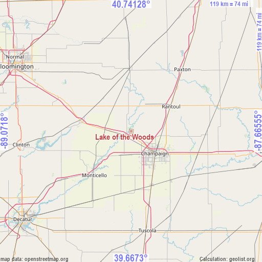
Lake of the Woods GPS coordinates[2]
40° 12' 23.112" North, 88° 22' 7.212" West
| Map corner | latitude | longitude |
|---|---|---|
| Upper-left | 40.74128°, | -89.0718° |
| Center: | 40.20642°, | -88.36867° |
| Lower-right: | 39.6673°, | -87.66555° |
| Map W x H: | 119.4×119.4 km | = 74.2×74.2mi |
| max Lat: | 71.29058° ⇑44.4% North |
| Lake of the Woods: | 40.20642° |
| min Lat: | ⇓55.6% South 19.06759° |
| min Long | Lake of the Woo | max Long |
| -171.73463° | -88.36867° | -66.98998° |
| W 45.6%⇐ | ⇒54.4% E |
Elevation
Elevation of Lake of the Woods is 229 m = 751 ft, and this is 65.8 m = 216 ft below average elevation for this country.
| Max E: |
3189 m = 10463 ft | 42.3% |
| Avg. | 294.8 m = 967 ft | |
| Lake of the Woods | 229 m = 751 ft | |
Min E: |
-60 m = -197 ft | 57.7% |
See also: United States elevation on elevation.city.
Geographical zone
Lake of the Woods is located in North temperate zone (between Tropic of Cancer and the Arctic Circle). Distance of this Northern Tropic circle is 1864.6 km =1158.6 mi to South.| Distance of | km | miles | from Lake of the Woods |
|---|---|---|---|
| North Pole | 5536.5 | 3440.2 | to North |
| Arctic Circle | 2930.6 | 1821 | to North |
| Tropic Cancer | 1864.6 | 1158.6 | to South |
| Equator | 4470.5 | 2777.8 | to South |


Nearby cities:
15 places around Lake of the Woods: (largest is in red/bold)
• Champaign
14.6 km =9.1 mi,  133°
133°
• Farmer City
23.6 km =14.7 mi,  280°
280°
• Fisher
12.1 km =7.5 mi,  7°
7°
• Gibson City
28.1 km =17.5 mi,  357°
357°
• Mahomet
3.3 km =2.1 mi,  247°
247°
• Mansfield
11.7 km =7.3 mi,  272°
272°
• Monticello
26.4 km =16.4 mi,  221°
221°
• Philo
28.5 km =17.7 mi,  141°
141°
• Rantoul
21.3 km =13.2 mi,  57°
57°
• Saint Joseph
29.7 km =18.5 mi,  110°
110°
• Savoy
19.6 km =12.2 mi,  149°
149°
• Saybrook
27.9 km =17.3 mi,  331°
331°
• Thomasboro
16.1 km =10 mi,  75°
75°
• Tolono
26.2 km =16.3 mi,  159°
159°
• Urbana
17.4 km =10.8 mi, 127°
Sources, notices
• [Note1] Compared only with cities in United States existing in our database
• [Src1] Map data: © OpenStreetMap contributors (CC-BY-SA)
• [Src2] Other city data from geonames.org with taken over terms of usage.
• [Src3] Geographical zone / Annual Mean Temperature by Robert A. Rohde @ Wikipedia
