Hoopeston geodata
Hoopeston (Illinois) is a populated place; located in United States in America/Chicago (GMT-5) time zone. With population of 5,220 people, there are 6974 cities with bigger population in this country. Compared to other cities in United States, 58.6% of cities are located further ↓South; 51.3% of cities are located further →East and 56.4% of cities have lower elevation than Hoopeston. Note1


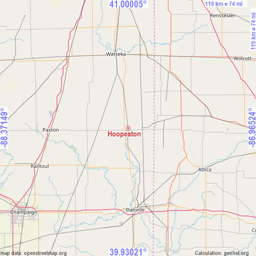
Hoopeston GPS coordinates[2]
40° 28' 2.136" North, 87° 40' 6.096" West
| Map corner | latitude | longitude |
|---|---|---|
| Upper-left | 41.00005°, | -88.37149° |
| Center: | 40.46726°, | -87.66836° |
| Lower-right: | 39.93021°, | -86.96524° |
| Map W x H: | 119×119 km | = 73.9×73.9mi |
| max Lat: | 71.29058° ⇑41.4% North |
| Hoopeston: | 40.46726° |
| min Lat: | ⇓58.6% South 19.06759° |
| min Long | Hoopeston | max Long |
| -171.73463° | -87.66836° | -66.98998° |
| W 48.7%⇐ | ⇒51.3% E |
Elevation
Elevation of Hoopeston is 224 m = 735 ft, and this is 70.8 m = 232 ft below average elevation for this country.
| Max E: |
3189 m = 10463 ft | 43.6% |
| Avg. | 294.8 m = 967 ft | |
| Hoopeston | 224 m = 735 ft | |
Min E: |
-60 m = -197 ft | 56.4% |
See also: United States elevation on elevation.city.
Geographical zone
Hoopeston is located in North temperate zone (between Tropic of Cancer and the Arctic Circle). Distance of this Northern Tropic circle is 1893.6 km =1176.6 mi to South.| Distance of | km | miles | from Hoopeston |
|---|---|---|---|
| North Pole | 5507.5 | 3422.2 | to North |
| Arctic Circle | 2901.6 | 1803 | to North |
| Tropic Cancer | 1893.6 | 1176.6 | to South |
| Equator | 4499.5 | 2795.9 | to South |


Nearby cities:
15 places around Hoopeston: (largest is in red/bold)
• Bismarck
23.2 km =14.4 mi,  167°
167°
• Boswell
25.2 km =15.7 mi,  76°
76°
• Buckley
34.4 km =21.4 mi,  294°
294°
• Cissna Park
21.9 km =13.6 mi,  299°
299°
• Fowler
33.7 km =20.9 mi,  60°
60°
• Gifford
34.9 km =21.7 mi,  239°
239°
• Milford
18.1 km =11.2 mi,  352°
352°
• Oxford
36 km =22.4 mi, 80°
• Paxton
36.1 km =22.4 mi,  268°
268°
• Potomac
21.2 km =13.2 mi,  211°
211°
• Rankin
19.3 km =12 mi, 269°
• Rossville
9.8 km =6.1 mi,  180°
180°
• Sheldon
34.7 km =21.6 mi,  14°
14°
• Watseka
34.8 km =21.6 mi, 350°
• West Lebanon
32.4 km =20.1 mi,  132°
132°
Sources, notices
• [Note1] Compared only with cities in United States existing in our database
• [Src1] Map data: © OpenStreetMap contributors (CC-BY-SA)
• [Src2] Other city data from geonames.org with taken over terms of usage.
• [Src3] Geographical zone / Annual Mean Temperature by Robert A. Rohde @ Wikipedia
