Roscoe geodata
Roscoe (Illinois) is a populated place; located in United States in America/Chicago (GMT-5) time zone. With population of 10,565 people, there are 4311 cities with bigger population in this country. Compared to other cities in United States, 79% of cities are located further ↓South; 56.1% of cities are located further →East and 57.5% of cities have lower elevation than Roscoe. Note1


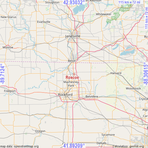
Roscoe GPS coordinates[2]
42° 24' 48.06" North, 89° 0' 33.372" West
| Map corner | latitude | longitude |
|---|---|---|
| Upper-left | 42.93032°, | -89.7124° |
| Center: | 42.41335°, | -89.00927° |
| Lower-right: | 41.89209°, | -88.30615° |
| Map W x H: | 115.4×115.4 km | = 71.7×71.7mi |
| max Lat: | 71.29058° ⇑21% North |
| Roscoe: | 42.41335° |
| min Lat: | ⇓79% South 19.06759° |
| min Long | Roscoe | max Long |
| -171.73463° | -89.00927° | -66.98998° |
| W 43.9%⇐ | ⇒56.1% E |
Elevation
Elevation of Roscoe is 228 m = 748 ft, and this is 66.8 m = 219 ft below average elevation for this country.
| Max E: |
3189 m = 10463 ft | 42.5% |
| Avg. | 294.8 m = 967 ft | |
| Roscoe | 228 m = 748 ft | |
Min E: |
-60 m = -197 ft | 57.5% |
See also: United States elevation on elevation.city.
Geographical zone
Roscoe is located in North temperate zone (between Tropic of Cancer and the Arctic Circle). Distance of this Northern Tropic circle is 2110 km =1311.1 mi to South.| Distance of | km | miles | from Roscoe |
|---|---|---|---|
| North Pole | 5291.1 | 3287.7 | to North |
| Arctic Circle | 2685.3 | 1668.6 | to North |
| Tropic Cancer | 2110 | 1311.1 | to South |
| Equator | 4715.9 | 2930.3 | to South |


Nearby cities:
15 places around Roscoe: (largest is in red/bold)
• Beloit
10.7 km =6.6 mi,  350°
350°
• Belvidere
21.4 km =13.3 mi,  140°
140°
• Capron
22.1 km =13.7 mi,  93°
93°
• Cherry Valley
20.5 km =12.7 mi,  165°
165°
• Clinton
19.9 km =12.4 mi,  36°
36°
• Edgewood
20.5 km =12.7 mi,  159°
159°
• Loves Park
11.1 km =6.9 mi,  201°
201°
• Machesney Park
7.7 km =4.8 mi, 198°
• Poplar Grove
16.2 km =10.1 mi,  108°
108°
• Rockford
17.3 km =10.7 mi, 203°
• Rockton
6.8 km =4.2 mi,  310°
310°
• Sharon
25 km =15.5 mi,  66°
66°
• South Beloit
9.1 km =5.7 mi, 345°
• Timberlane
15 km =9.3 mi,  125°
125°
• Winnebago
25.1 km =15.6 mi,  229°
229°
Sources, notices
• [Note1] Compared only with cities in United States existing in our database
• [Src1] Map data: © OpenStreetMap contributors (CC-BY-SA)
• [Src2] Other city data from geonames.org with taken over terms of usage.
• [Src3] Geographical zone / Annual Mean Temperature by Robert A. Rohde @ Wikipedia
