Capron geodata
Capron (Illinois) is a populated place; located in United States in America/Chicago (GMT-5) time zone. With population of 1,348 people, there are 14358 cities with bigger population in this country. Compared to other cities in United States, 78.9% of cities are located further ↓South; 55.5% of cities are located further →East and 69% of cities have lower elevation than Capron. Note1


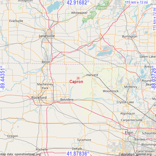
Capron GPS coordinates[2]
42° 23' 59.064" North, 88° 44' 25.368" West
| Map corner | latitude | longitude |
|---|---|---|
| Upper-left | 42.91682°, | -89.44351° |
| Center: | 42.39974°, | -88.74038° |
| Lower-right: | 41.87836°, | -88.03726° |
| Map W x H: | 115.5×115.5 km | = 71.8×71.8mi |
| max Lat: | 71.29058° ⇑21.1% North |
| Capron: | 42.39974° |
| min Lat: | ⇓78.9% South 19.06759° |
| min Long | Capron | max Long |
| -171.73463° | -88.74038° | -66.98998° |
| W 44.5%⇐ | ⇒55.5% E |
Elevation
Elevation of Capron is 281 m = 922 ft, and this is 13.8 m = 45 ft below average elevation for this country.
| Max E: |
3189 m = 10463 ft | 31% |
| Avg. | 294.8 m = 967 ft | |
| Capron | 281 m = 922 ft | |
Min E: |
-60 m = -197 ft | 69% |
See also: United States elevation on elevation.city.
Geographical zone
Capron is located in North temperate zone (between Tropic of Cancer and the Arctic Circle). Distance of this Northern Tropic circle is 2108.5 km =1310.2 mi to South.| Distance of | km | miles | from Capron |
|---|---|---|---|
| North Pole | 5292.7 | 3288.7 | to North |
| Arctic Circle | 2686.8 | 1669.5 | to North |
| Tropic Cancer | 2108.5 | 1310.2 | to South |
| Equator | 4714.4 | 2929.4 | to South |


Nearby cities:
15 places around Capron: (largest is in red/bold)
• Belvidere
17.3 km =10.7 mi,  209°
209°
• Cherry Valley
25.1 km =15.6 mi,  223°
223°
• Clinton
20.3 km =12.6 mi,  329°
329°
• Darien
22.6 km =14 mi,  6°
6°
• Delavan Lake
22.3 km =13.9 mi,  23°
23°
• Edgewood
23.1 km =14.4 mi, 220°
• Fontana
21.6 km =13.4 mi,  38°
38°
• Harvard
10.7 km =6.6 mi,  76°
76°
• Marengo
20 km =12.4 mi,  147°
147°
• Poplar Grove
7.6 km =4.7 mi,  242°
242°
• Roscoe
22.1 km =13.7 mi,  273°
273°
• Sharon
11.5 km =7.1 mi,  4°
4°
• Timberlane
12.3 km =7.6 mi,  233°
233°
• Union
24.7 km =15.3 mi,  138°
138°
• Walworth
18.6 km =11.6 mi, 38°
Sources, notices
• [Note1] Compared only with cities in United States existing in our database
• [Src1] Map data: © OpenStreetMap contributors (CC-BY-SA)
• [Src2] Other city data from geonames.org with taken over terms of usage.
• [Src3] Geographical zone / Annual Mean Temperature by Robert A. Rohde @ Wikipedia
