Waterman geodata
Waterman (Illinois) is a populated place; located in United States in America/Chicago (GMT-5) time zone. With population of 1,494 people, there are 13679 cities with bigger population in this country. Compared to other cities in United States, 73.7% of cities are located further ↓South; 55.5% of cities are located further →East and 63.7% of cities have lower elevation than Waterman. Note1


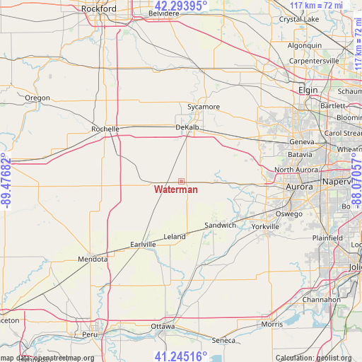
Waterman GPS coordinates[2]
41° 46' 18.12" North, 88° 46' 25.284" West
| Map corner | latitude | longitude |
|---|---|---|
| Upper-left | 42.29395°, | -89.47682° |
| Center: | 41.7717°, | -88.77369° |
| Lower-right: | 41.24516°, | -88.07057° |
| Map W x H: | 116.6×116.6 km | = 72.5×72.5mi |
| max Lat: | 71.29058° ⇑26.3% North |
| Waterman: | 41.7717° |
| min Lat: | ⇓73.7% South 19.06759° |
| min Long | Waterman | max Long |
| -171.73463° | -88.77369° | -66.98998° |
| W 44.5%⇐ | ⇒55.5% E |
Elevation
Elevation of Waterman is 256 m = 840 ft, and this is 38.8 m = 127 ft below average elevation for this country.
| Max E: |
3189 m = 10463 ft | 36.3% |
| Avg. | 294.8 m = 967 ft | |
| Waterman | 256 m = 840 ft | |
Min E: |
-60 m = -197 ft | 63.7% |
See also: United States elevation on elevation.city.
Geographical zone
Waterman is located in North temperate zone (between Tropic of Cancer and the Arctic Circle). Distance of this Northern Tropic circle is 2038.7 km =1266.8 mi to South.| Distance of | km | miles | from Waterman |
|---|---|---|---|
| North Pole | 5362.5 | 3332.1 | to North |
| Arctic Circle | 2756.6 | 1712.9 | to North |
| Tropic Cancer | 2038.7 | 1266.8 | to South |
| Equator | 4644.6 | 2886 | to South |


Nearby cities:
15 places around Waterman: (largest is in red/bold)
• Big Rock
18.8 km =11.7 mi,  92°
92°
• Cortland
17.9 km =11.1 mi,  23°
23°
• Creston
23.7 km =14.7 mi,  318°
318°
• DeKalb
17.6 km =10.9 mi,  6°
6°
• Earlville
23.7 km =14.7 mi,  211°
211°
• Hinckley
11 km =6.8 mi, 91°
• Lake Holiday
19.6 km =12.2 mi,  154°
154°
• Leland
17.8 km =11.1 mi,  186°
186°
• Malta
19 km =11.8 mi,  337°
337°
• Maple Park
20.9 km =13 mi,  43°
43°
• Paw Paw
19.5 km =12.1 mi,  241°
241°
• Plano
23.1 km =14.4 mi,  121°
121°
• Sandwich
18.8 km =11.7 mi,  137°
137°
• Shabbona
8.6 km =5.3 mi,  267°
267°
• Somonauk
17.2 km =10.7 mi, 153°
Sources, notices
• [Note1] Compared only with cities in United States existing in our database
• [Src1] Map data: © OpenStreetMap contributors (CC-BY-SA)
• [Src2] Other city data from geonames.org with taken over terms of usage.
• [Src3] Geographical zone / Annual Mean Temperature by Robert A. Rohde @ Wikipedia
