Cortland geodata
Cortland (Illinois) is a populated place; located in United States in America/Chicago (GMT-5) time zone. With population of 4,325 people, there are 7838 cities with bigger population in this country. Compared to other cities in United States, 74.9% of cities are located further ↓South; 55.4% of cities are located further →East and 68.2% of cities have lower elevation than Cortland. Note1


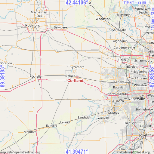
Cortland GPS coordinates[2]
41° 55' 12.108" North, 88° 41' 19.32" West
| Map corner | latitude | longitude |
|---|---|---|
| Upper-left | 42.44106°, | -89.39183° |
| Center: | 41.92003°, | -88.6887° |
| Lower-right: | 41.39471°, | -87.98558° |
| Map W x H: | 116.3×116.3 km | = 72.3×72.3mi |
| max Lat: | 71.29058° ⇑25.1% North |
| Cortland: | 41.92003° |
| min Lat: | ⇓74.9% South 19.06759° |
| min Long | Cortland | max Long |
| -171.73463° | -88.6887° | -66.98998° |
| W 44.6%⇐ | ⇒55.4% E |
Elevation
Elevation of Cortland is 277 m = 909 ft, and this is 17.8 m = 58 ft below average elevation for this country.
| Max E: |
3189 m = 10463 ft | 31.8% |
| Avg. | 294.8 m = 967 ft | |
| Cortland | 277 m = 909 ft | |
Min E: |
-60 m = -197 ft | 68.2% |
See also: United States elevation on elevation.city.
Geographical zone
Cortland is located in North temperate zone (between Tropic of Cancer and the Arctic Circle). Distance of this Northern Tropic circle is 2055.2 km =1277 mi to South.| Distance of | km | miles | from Cortland |
|---|---|---|---|
| North Pole | 5346 | 3321.8 | to North |
| Arctic Circle | 2740.1 | 1702.6 | to North |
| Tropic Cancer | 2055.2 | 1277 | to South |
| Equator | 4661.1 | 2896.3 | to South |


Nearby cities:
15 places around Cortland: (largest is in red/bold)
• Big Rock
21 km =13 mi,  145°
145°
• Burlington
18.8 km =11.7 mi,  38°
38°
• Creston
22.9 km =14.2 mi,  273°
273°
• DeKalb
5.2 km =3.2 mi,  281°
281°
• Elburn
18.2 km =11.3 mi,  99°
99°
• Genoa
19.7 km =12.2 mi,  358°
358°
• Hinckley
17.3 km =10.7 mi,  166°
166°
• Kingston
20.8 km =12.9 mi,  343°
343°
• Kirkland
23.4 km =14.5 mi,  325°
325°
• Lily Lake
17.7 km =11 mi,  79°
79°
• Malta
14.3 km =8.9 mi, 274°
• Maple Park
7.5 km =4.7 mi, 100°
• Shabbona
23 km =14.3 mi,  222°
222°
• Sycamore
7.7 km =4.8 mi,  1°
1°
• Waterman
17.9 km =11.1 mi,  203°
203°
Sources, notices
• [Note1] Compared only with cities in United States existing in our database
• [Src1] Map data: © OpenStreetMap contributors (CC-BY-SA)
• [Src2] Other city data from geonames.org with taken over terms of usage.
• [Src3] Geographical zone / Annual Mean Temperature by Robert A. Rohde @ Wikipedia
