DeKalb geodata
DeKalb (Illinois) is a populated place; located in United States in America/Chicago (GMT-5) time zone. With population of 43,211 people, there are 1105 cities with bigger population in this country. Compared to other cities in United States, 75% of cities are located further ↓South; 55.5% of cities are located further →East and 66.7% of cities have lower elevation than DeKalb. Note1


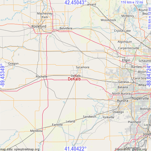
DeKalb GPS coordinates[2]
41° 55' 46.092" North, 88° 45' 1.296" West
| Map corner | latitude | longitude |
|---|---|---|
| Upper-left | 42.45043°, | -89.45349° |
| Center: | 41.92947°, | -88.75036° |
| Lower-right: | 41.40422°, | -88.04724° |
| Map W x H: | 116.3×116.3 km | = 72.3×72.3mi |
| max Lat: | 71.29058° ⇑25% North |
| DeKalb: | 41.92947° |
| min Lat: | ⇓75% South 19.06759° |
| min Long | DeKalb | max Long |
| -171.73463° | -88.75036° | -66.98998° |
| W 44.5%⇐ | ⇒55.5% E |
Elevation
Elevation of DeKalb is 270 m = 886 ft, and this is 24.8 m = 81 ft below average elevation for this country.
| Max E: |
3189 m = 10463 ft | 33.3% |
| Avg. | 294.8 m = 967 ft | |
| DeKalb | 270 m = 886 ft | |
Min E: |
-60 m = -197 ft | 66.7% |
See also: DeKalb elevation on elevation.city.
Geographical zone
DeKalb is located in North temperate zone (between Tropic of Cancer and the Arctic Circle). Distance of this Northern Tropic circle is 2056.2 km =1277.7 mi to South.| Distance of | km | miles | from DeKalb |
|---|---|---|---|
| North Pole | 5344.9 | 3321.2 | to North |
| Arctic Circle | 2739.1 | 1702 | to North |
| Tropic Cancer | 2056.2 | 1277.7 | to South |
| Equator | 4662.1 | 2896.9 | to South |


Nearby cities:
15 places around DeKalb: (largest is in red/bold)
• Big Rock
24.9 km =15.5 mi,  137°
137°
• Burlington
21.6 km =13.4 mi,  50°
50°
• Cortland
5.2 km =3.2 mi,  101°
101°
• Creston
17.7 km =11 mi,  270°
270°
• Elburn
23.4 km =14.5 mi, 100°
• Genoa
19.3 km =12 mi,  14°
14°
• Hinckley
20 km =12.4 mi,  153°
153°
• Kingston
18.9 km =11.7 mi,  357°
357°
• Kirkland
20 km =12.4 mi,  335°
335°
• Lily Lake
22.6 km =14 mi,  84°
84°
• Malta
9.1 km =5.7 mi, 270°
• Maple Park
12.7 km =7.9 mi, 101°
• Shabbona
20.8 km =12.9 mi,  210°
210°
• Sycamore
8.4 km =5.2 mi,  38°
38°
• Waterman
17.6 km =10.9 mi,  186°
186°
Sources, notices
• [Note1] Compared only with cities in United States existing in our database
• [Src1] Map data: © OpenStreetMap contributors (CC-BY-SA)
• [Src2] Other city data from geonames.org with taken over terms of usage.
• [Src3] Geographical zone / Annual Mean Temperature by Robert A. Rohde @ Wikipedia
