Watseka geodata
Watseka (Illinois) is a seat of a second-order administrative division; located in United States in America/Chicago (GMT-5) time zone. With population of 5,070 people, there are 7110 cities with bigger population in this country. Compared to other cities in United States, 62.8% of cities are located further ↓South; 51.7% of cities are located further →East and 51.1% of cities have higher elevation than Watseka. Note1
Administrative division(s):
- Level 1: Illinois
- Level 2: Iroquois County
- Level 3: Township of Middleport


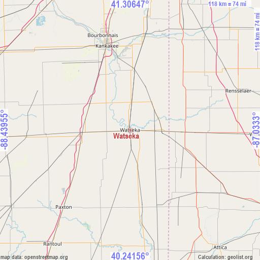
Watseka GPS coordinates[2]
40° 46' 34.14" North, 87° 44' 11.112" West
| Map corner | latitude | longitude |
|---|---|---|
| Upper-left | 41.30647°, | -88.43955° |
| Center: | 40.77615°, | -87.73642° |
| Lower-right: | 40.24156°, | -87.0333° |
| Map W x H: | 118.4×118.4 km | = 73.6×73.6mi |
| max Lat: | 71.29058° ⇑37.2% North |
| Watseka: | 40.77615° |
| min Lat: | ⇓62.8% South 19.06759° |
| min Long | Watseka | max Long |
| -171.73463° | -87.73642° | -66.98998° |
| W 48.3%⇐ | ⇒51.7% E |
Elevation
Elevation of Watseka is 194 m = 636 ft, and this is 100.8 m = 331 ft below average elevation for this country.
| Max E: |
3189 m = 10463 ft | 51.1% |
| Avg. | 294.8 m = 967 ft | |
| Watseka | 194 m = 636 ft | |
Min E: |
-60 m = -197 ft | 48.9% |
See also: United States elevation on elevation.city.
Geographical zone
Watseka is located in North temperate zone (between Tropic of Cancer and the Arctic Circle). Distance of this Northern Tropic circle is 1928 km =1198 mi to South.| Distance of | km | miles | from Watseka |
|---|---|---|---|
| North Pole | 5473.2 | 3400.9 | to North |
| Arctic Circle | 2867.3 | 1781.7 | to North |
| Tropic Cancer | 1928 | 1198 | to South |
| Equator | 4533.9 | 2817.2 | to South |


Nearby cities:
15 places around Watseka: (largest is in red/bold)
• Ashkum
21.7 km =13.5 mi,  302°
302°
• Brook
32.9 km =20.4 mi,  72°
72°
• Buckley
32.3 km =20.1 mi,  231°
231°
• Chebanse
29.1 km =18.1 mi,  330°
330°
• Cissna Park
27 km =16.8 mi,  209°
209°
• Clifton
24.3 km =15.1 mi,  316°
316°
• Crescent City
10.3 km =6.4 mi,  266°
266°
• Danforth
20.9 km =13 mi,  283°
283°
• Gilman
21.6 km =13.4 mi, 267°
• Kentland
24.5 km =15.2 mi,  91°
91°
• Milford
16.8 km =10.4 mi,  168°
168°
• Morocco
30.4 km =18.9 mi,  51°
51°
• Onarga
23.7 km =14.7 mi,  253°
253°
• Saint Anne
27.7 km =17.2 mi,  3°
3°
• Sheldon
14.5 km =9 mi, 93°
Sources, notices
• [Note1] Compared only with cities in United States existing in our database
• [Src1] Map data: © OpenStreetMap contributors (CC-BY-SA)
• [Src2] Other city data from geonames.org with taken over terms of usage.
• [Src3] Geographical zone / Annual Mean Temperature by Robert A. Rohde @ Wikipedia
