Milford geodata
Milford (Illinois) is a populated place; located in United States in America/Chicago (GMT-5) time zone. With population of 1,242 people, there are 14897 cities with bigger population in this country. Compared to other cities in United States, 60.4% of cities are located further ↓South; 51.4% of cities are located further →East and 51.9% of cities have lower elevation than Milford. Note1


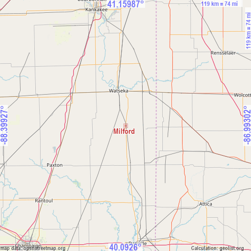
Milford GPS coordinates[2]
40° 37' 42.132" North, 87° 41' 46.104" West
| Map corner | latitude | longitude |
|---|---|---|
| Upper-left | 41.15987°, | -88.39927° |
| Center: | 40.62837°, | -87.69614° |
| Lower-right: | 40.0926°, | -86.99302° |
| Map W x H: | 118.7×118.7 km | = 73.8×73.8mi |
| max Lat: | 71.29058° ⇑39.6% North |
| Milford: | 40.62837° |
| min Lat: | ⇓60.4% South 19.06759° |
| min Long | Milford | max Long |
| -171.73463° | -87.69614° | -66.98998° |
| W 48.6%⇐ | ⇒51.4% E |
Elevation
Elevation of Milford is 206 m = 676 ft, and this is 88.8 m = 291 ft below average elevation for this country.
| Max E: |
3189 m = 10463 ft | 48.1% |
| Avg. | 294.8 m = 967 ft | |
| Milford | 206 m = 676 ft | |
Min E: |
-60 m = -197 ft | 51.9% |
See also: United States elevation on elevation.city.
Geographical zone
Milford is located in North temperate zone (between Tropic of Cancer and the Arctic Circle). Distance of this Northern Tropic circle is 1911.5 km =1187.8 mi to South.| Distance of | km | miles | from Milford |
|---|---|---|---|
| North Pole | 5489.6 | 3411.1 | to North |
| Arctic Circle | 2883.7 | 1791.8 | to North |
| Tropic Cancer | 1911.5 | 1187.8 | to South |
| Equator | 4517.5 | 2807 | to South |


Nearby cities:
15 places around Milford: (largest is in red/bold)
• Ashkum
35.5 km =22.1 mi,  322°
322°
• Boswell
29.4 km =18.3 mi,  113°
113°
• Buckley
29.1 km =18.1 mi,  263°
263°
• Cissna Park
18.1 km =11.2 mi,  246°
246°
• Crescent City
20.9 km =13 mi, 318°
• Danforth
31.9 km =19.8 mi,  311°
311°
• Fowler
31.7 km =19.7 mi,  92°
92°
• Gilman
29.3 km =18.2 mi,  301°
301°
• Hoopeston
18.1 km =11.2 mi,  172°
172°
• Kentland
26.4 km =16.4 mi,  53°
53°
• Onarga
27.9 km =17.3 mi,  290°
290°
• Rankin
24.8 km =15.4 mi,  222°
222°
• Rossville
27.8 km =17.3 mi,  175°
175°
• Sheldon
19.2 km =11.9 mi,  35°
35°
• Watseka
16.8 km =10.4 mi,  348°
348°
Sources, notices
• [Note1] Compared only with cities in United States existing in our database
• [Src1] Map data: © OpenStreetMap contributors (CC-BY-SA)
• [Src2] Other city data from geonames.org with taken over terms of usage.
• [Src3] Geographical zone / Annual Mean Temperature by Robert A. Rohde @ Wikipedia
