Kentland geodata
Kentland (Indiana) is a seat of a second-order administrative division; located in United States in America/Chicago (GMT-5) time zone. With population of 1,698 people, there are 12916 cities with bigger population in this country. Compared to other cities in United States, 62.7% of cities are located further ↓South; 50.7% of cities are located further →East and 53.2% of cities have lower elevation than Kentland. Note1


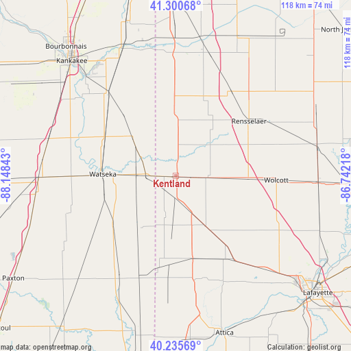
Kentland GPS coordinates[2]
40° 46' 13.152" North, 87° 26' 43.08" West
| Map corner | latitude | longitude |
|---|---|---|
| Upper-left | 41.30068°, | -88.14843° |
| Center: | 40.77032°, | -87.4453° |
| Lower-right: | 40.23569°, | -86.74218° |
| Map W x H: | 118.4×118.4 km | = 73.6×73.6mi |
| max Lat: | 71.29058° ⇑37.3% North |
| Kentland: | 40.77032° |
| min Lat: | ⇓62.7% South 19.06759° |
| min Long | Kentland | max Long |
| -171.73463° | -87.4453° | -66.98998° |
| W 49.3%⇐ | ⇒50.7% E |
Elevation
Elevation of Kentland is 211 m = 692 ft, and this is 83.8 m = 275 ft below average elevation for this country.
| Max E: |
3189 m = 10463 ft | 46.8% |
| Avg. | 294.8 m = 967 ft | |
| Kentland | 211 m = 692 ft | |
Min E: |
-60 m = -197 ft | 53.2% |
See also: United States elevation on elevation.city.
Geographical zone
Kentland is located in North temperate zone (between Tropic of Cancer and the Arctic Circle). Distance of this Northern Tropic circle is 1927.3 km =1197.6 mi to South.| Distance of | km | miles | from Kentland |
|---|---|---|---|
| North Pole | 5473.8 | 3401.3 | to North |
| Arctic Circle | 2867.9 | 1782 | to North |
| Tropic Cancer | 1927.3 | 1197.6 | to South |
| Equator | 4533.2 | 2816.8 | to South |


Nearby cities:
15 places around Kentland: (largest is in red/bold)
• Boswell
28.3 km =17.6 mi,  168°
168°
• Brook
12.7 km =7.9 mi,  32°
32°
• Crescent City
34.8 km =21.6 mi,  269°
269°
• Fowler
20 km =12.4 mi,  148°
148°
• Goodland
12.8 km =8 mi,  93°
93°
• Hopkins Park
35.9 km =22.3 mi,  335°
335°
• Milford
26.4 km =16.4 mi,  233°
233°
• Morocco
19.6 km =12.2 mi,  358°
358°
• Oxford
32.5 km =20.2 mi, 149°
• Remington
24.8 km =15.4 mi, 92°
• Rensselaer
30.9 km =19.2 mi,  53°
53°
• Saint Anne
36.2 km =22.5 mi,  321°
321°
• Sheldon
10 km =6.2 mi, 269°
• Watseka
24.5 km =15.2 mi, 271°
• Wolcott
34 km =21.1 mi, 92°
Sources, notices
• [Note1] Compared only with cities in United States existing in our database
• [Src1] Map data: © OpenStreetMap contributors (CC-BY-SA)
• [Src2] Other city data from geonames.org with taken over terms of usage.
• [Src3] Geographical zone / Annual Mean Temperature by Robert A. Rohde @ Wikipedia
