Winthrop Harbor geodata
Winthrop Harbor (Illinois) is a populated place; located in United States in America/Chicago (GMT-5) time zone. With population of 6,818 people, there are 5915 cities with bigger population in this country. Compared to other cities in United States, 79.6% of cities are located further ↓South; 52% of cities are located further →East and 50.8% of cities have higher elevation than Winthrop Harbor. Note1


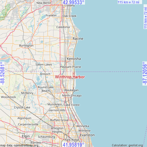
Winthrop Harbor GPS coordinates[2]
42° 28' 44.076" North, 87° 49' 25.248" West
| Map corner | latitude | longitude |
|---|---|---|
| Upper-left | 42.99533°, | -88.52681° |
| Center: | 42.47891°, | -87.82368° |
| Lower-right: | 41.95819°, | -87.12056° |
| Map W x H: | 115.3×115.3 km | = 71.6×71.6mi |
| max Lat: | 71.29058° ⇑20.4% North |
| Winthrop Harbor: | 42.47891° |
| min Lat: | ⇓79.6% South 19.06759° |
| min Long | Winthrop Harbor | max Long |
| -171.73463° | -87.82368° | -66.98998° |
| W 48%⇐ | ⇒52% E |
Elevation
Elevation of Winthrop Harbor is 195 m = 640 ft, and this is 99.8 m = 327 ft below average elevation for this country.
| Max E: |
3189 m = 10463 ft | 50.8% |
| Avg. | 294.8 m = 967 ft | |
| Winthrop Harbor | 195 m = 640 ft | |
Min E: |
-60 m = -197 ft | 49.2% |
See also: United States elevation on elevation.city.
Geographical zone
Winthrop Harbor is located in North temperate zone (between Tropic of Cancer and the Arctic Circle). Distance of this Northern Tropic circle is 2117.3 km =1315.6 mi to South.| Distance of | km | miles | from Winthrop Harbor |
|---|---|---|---|
| North Pole | 5283.8 | 3283.2 | to North |
| Arctic Circle | 2678 | 1664 | to North |
| Tropic Cancer | 2117.3 | 1315.6 | to South |
| Equator | 4723.2 | 2934.9 | to South |


Nearby cities:
15 places around Winthrop Harbor: (largest is in red/bold)
• Beach Park
6.9 km =4.3 mi,  203°
203°
• Gages Lake
19.2 km =11.9 mi,  222°
222°
• Grandwood Park
16.4 km =10.2 mi,  234°
234°
• Gurnee
13.7 km =8.5 mi,  208°
208°
• Kenosha
11.8 km =7.3 mi,  0°
0°
• Lake Shangrila
20.5 km =12.7 mi,  278°
278°
• Lindenhurst
18.3 km =11.4 mi,  245°
245°
• North Chicago
17.1 km =10.6 mi,  184°
184°
• Park City
15.3 km =9.5 mi, 198°
• Pleasant Prairie
12.2 km =7.6 mi,  312°
312°
• Somers
19.3 km =12 mi,  338°
338°
• Third Lake
19.3 km =12 mi, 232°
• Wadsworth
9.9 km =6.2 mi,  235°
235°
• Waukegan
12.9 km =8 mi,  187°
187°
• Zion
3.7 km =2.3 mi, 191°
Sources, notices
• [Note1] Compared only with cities in United States existing in our database
• [Src1] Map data: © OpenStreetMap contributors (CC-BY-SA)
• [Src2] Other city data from geonames.org with taken over terms of usage.
• [Src3] Geographical zone / Annual Mean Temperature by Robert A. Rohde @ Wikipedia
